Ethnographic Maps of the 19th Century
Ethnographic Maps of the 19th Century
This Web page provides access to some of the 19th-century ethnographic maps that are held at the University of Chicago Library's Map Collection.
Most of these maps show the distribution of particular ethnic groups or languages. A few show the geography of other aspects of culture.
The majority of the maps concentrate either on parts of the colonial world in which the ethnic distribution was only coming to be known by Western scholars--or else on one of those regions of Europe or the Middle East where the geography of ethnicity conflicted with political boundaries. There are also two urban maps.
The maps reflect the period in which they were produced. They show the world as it seemed to their compilers. Several of the names that appear on the maps (e.g., Kaffir and Ruthenian) are now little used. The racial classifications and Leo Frobenius's Kulturkreise now seem old-fashioned. And, of course, some of the ethnic boundaries (for example, those between Germans and Poles and between Armenians and Turks) have changed radically.
Most of these maps are "choropleth" maps: they show ethnicity and language in solid colors. Choropleth thematic maps are said to have been invented in the early 19th century. Such maps are easy to read, but they are not very good at portraying complexity, for example areas in which ethnic groups and languages are intermingled.
Virtually all of these maps were produced by scholars for other scholars. Many of their compilers were associated with one of the new geography departments at expanding continental universities. More than half the maps are offprints from major journals like Petermanns Geographische Mitt(h)eilungen and the Bulletin de la Société de géographie.
The maps shown are a tiny subset of all the ethnographic maps produced in the 19th century. Additional titles in North American libraries can be found by searching with Library of Congress subject headings. Maps of ethnicity use the (somewhat unidiomatic) subject heading "Ethnology--[Place name]--Maps." Maps concentrating on language have subject headings of the form "[Place name]--Languages--Maps." Maps focussing on other culture traits can have other subject headings, but place names and the word "Maps" are nearly always present. Note that ethnographic maps that appeared as parts of books or journal articles are only likely to be listed in library catalogs if a map library holds and has cataloged an offprint.
The maps were scanned at 400 dpi using NextImage software and were saved as tiff files
You can access these files in two different ways:
[1] Click on the thumbnails below to see the files in a program called Zoomify. Zoomify breaks the original tiff files into tiny jpegs, so you can zoom in and out and move around quickly and efficiently. Zoomify requires Flash and so won't work on many mobile phones.
[2] You can also see the files through Luna. Luna, like Zoomify, allows you to zoom in and out and to move around. It also allows download of jpeg versions of the files (click "Export"). To access the Luna files, click on the "Click here for Luna version" button.
The original tiff files are also available. E-mail from the "Questions about this page?" button below.
Downloaded files are freely available for personal or scholarly use. If you use the images in a publication, we expect that you will mention that the original maps--and the files--are from the University of Chicago Library's Map Collection.
Several people contributed to the construction of this Web site. Joel Thomas of the Map Collection did nearly all the scanning, image preparation, and cataloging, and did some conservation work as well. Renee Martonik of the Cataloging Department provided advice on the latest rules for cataloging Internet resources. Kathleen Degnan of the Digital Library Development Center did the necessary server preparation. Tod Olson of the Integrated Library Systems unit solved a problem with diacritics in Romanized Cyrillic. Miles Kimball of Texas Tech University reminded Map Collection staff in the course of a research visit in the fall of 2011 of how much 19th-century ethnographic cartography is held at the Collection. Bridget Madden of the University of Chicago's Visual Resources Center and Charles Blair of the Library's Digital Library Development Center developed a protocol in 2015 that allows access via Luna. And Bobby Butler and Emily Thompson of the Map Collection edited these pages to point to the Luna versions..
The maps are listed by date.
Comments are welcome.
--CW
| Image | Title Information | Subject Headings | Description |
|---|---|---|---|
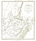 |
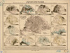
Afrique, au Nord-Est de la Colonie du Cap : dressée pour montrer la position relative des fermiers émigrans et des tribus natives / par le Capitaine W.C. Harris, du Corps des Ingénieurs de Bombay, Mai 1837 ; dessiné et gravé par Ambroise Tardieu. | Ethnology--Africa, Southern--Maps. | Scale 1:5,000,000. [Paris : Société de géographie], 1838. 1 map : col. ; 23 x 20 cm. |
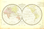 |
Mappemonde en deux hémisphères : indication des races d'hommes qui ont peuplé le globe / dressée par Fx. Ansart pour l'usage des collèges ; dessiné par Fremin ; gravé par Artus ; écrit par Hacq. | Ethnology--Maps. World maps. |
Scale [ca. 1:85,000,000]. [Paris? : s.n.], 1838. 1 map : col. ; 2 hemispheres, each 24 cm. in diam., on sheet 35 x 54 cm. |
 |
Map to illustrate Professor Max Müller's "Suggestions" for the assistance of officers in learning the languages of the seat of war in the East / drawn by Augustus Petermann, 1854 ; lith. by A. Petermann. | Turkey--Languages--Maps. Balkan Peninsula--Languages--Maps. |
Scale [ca. 1:6,000,000]. [London : Williams and Norgate, 1855]. 1 map : col. ; 32 x 46 cm. |
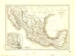 |
Essai d'une carte ethnographique du Mexique : d'après les travaux de Clavigero, de Humboldt, de Beltrami, de Stephens, de Duflot de Mofras, et de Brasseur de Bourbourg / par V.A. Malte-Brun ; gravé par Erhard. | Ethnology--Mexico--Maps. Indians of Mexico--Maps. |
Scale 1:7,000,000. [France : s.n.], 1864. 1 map : col. ; 32 x 45 cm. |
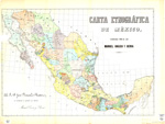 |
Carta etnográfica de México / formada por el Lic. Manuel Orozco y Berra. | Indians of Mexico--Maps. | Scale [ca. 1:4,200,000]. México] : Lit de Salazar, [1864?]. 1 map : col. ; 50 x 72 cm. |
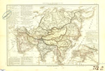 |
Carte politique et ethnographique de l'Asie / par MMrs. Drioux et Ch. Leroy ; gravé par Jenotte. | Ethnology--Asia--Maps. Asia -- Maps. |
Scale [ca. 1:28,500,000]. Paris : Librairie classique d'Eugène Belin, [1867?]. 1 map : col. ; 30 x 43 cm. |
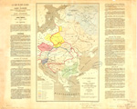 |
Carte linguistique, ethnographique, et politique actuelle de l'Europe orientale, Russie, Autriche, Turquie / par Casimir Delamarre ; gravé chez Erhard. | Europe, Eastern--Languages--Maps. | Scale [ca. 1:6,000,000] . [Paris] : Lanée, éditeur : Dentu, éditeur, 1868. 1 map : col. ; 47 x 30 cm. |
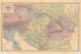 |
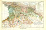
Völker- und Sprachen-Karte von Österreich und den Unter-Donau-Ländern / zusammengestellt von H. Kiepert. | Ethnology--Austria--Maps. Ethnology--Hungary--Maps. Ethnology--Balkan Peninsula--Maps. |
Scale 1:3,000,000. Berlin : D. Reimer, 1869. 1 map : col. ; 36 x 58 cm. |
 |
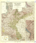
Völker[-] und Sprachen-Karte von Deutschland und den Nachbarländern / zusammengestellt von H. Kiepert. | Ethnology--Germany--Maps. Ethnology--Poland--Maps. Ethnology--Europe, Central--Maps. |
Scale 1:3,000,000. Berlin : D. Reimer, [1872]. 1 map : col. ; 42 x 54 cm. |
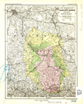 |
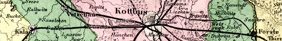
Das Sprachgebiet der Lausitzer Wenden, 1550-1872 / von Richard Andree. | Sorbs--Germany--Maps. Sorbs--Germany--History--Maps. |
Scale 1:750,000. Gotha : Justus Perthes, 1873. 1 map : col. 24 x 19 cm. |
 |
Die neueste Eintheilung, die türkischen Gebiete & die Confessionen in der Türkei / von A. Petermann ; bearbeitet von H. Habenicht. | Balkan Peninsula--Balkan Peninsula--Maps. Turks--Balkan peninsula--Maps. |
Scale 1:2,500,000. Gotha : Justus Perthes, 1876. 1 map : col. ; 33 x 45 cm. |
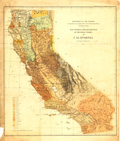 |
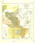
Map showing the distribution of the Indian tribes in California : to illustrate report of Stephen Powers / Department of the Interior, U.S. Geographical and Geological Survey of the Rocky Mountain Region. | Indians of North America--California--Maps. Indians of North America--California--Languages--Maps. |
Scale [ca. 1:1,810,000]. [Washington, D.C.] : Geographical and Geological Survey of the Rocky Mountain Region, 1877. 1 map : col. ; 64 x 56 cm. |
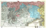 |
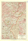
Deutsche & Romanen in Süd-Tirol & Venetien / nach Chr. Schneller ; von A. Petermann. | Ethnology--Italy--Bolzano (Province)--Maps. Ethnology--Italy--Friuli-Venezia Giulia--Maps. |
Scale 1:740,000. Gotha : Justus Perthes, 1877. 1 map : col. ; 27 x 44 cm. |
 |
Ethnographische Karte des Russischen Reiches, nebst Andeutung der hauptsächlichen Völkergrenzen in den Nachbargebieten : hauptsächlich nach Rittich und Venjukoff / von A. Petermann ; bearbeitet v. Hanemann. | Ethnology--Russia--Maps. | Scale 1:20,000,000. Gotha : Justus Perthes, 1877. 1 map : col. ; 33 x 42 cm. |
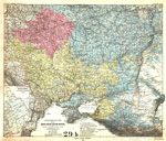 |
Vertheilung der Gross-, Weiss- & Klein-Russen, nach A.F. Rittich / von A. Petermann. | Ethnology--Russia, Western--Maps. Slavs--Russia, Western--Maps. |
Scale 1:3,700,000. Gotha : Justus Perthes, 1878. 1 map : col. ; 44 x 53 cm. |
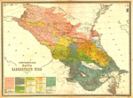 |
Этнографическая карта Кавказскаго края [Ėtnograficheskai͡a karta Kavkazskago krai͡a] / составленная по новѣйшим свѣдѣніям А. Риттихом [sostavlennai͡a po novi͡eĭshim svi͡edi͡enīi͡am A. Rittikhom]. | Ethnology--Caucasus, South--Maps. | Scale 1:1,080,000. С[анкт] Петербург [S[ankt] Peterburg] : КартограФическое зав. А. Ильина [Kartograficheskoe zav. A. Il'ina], [1878?]. 1 map : col. ; 73 x 99 cm. |
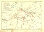 |
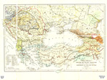
Carte ethnographique du Ferghanah / par C.E. de Ujfalvy, 1877 ; dessinée par J. Hansen, d'après la carte de A. Fedchenko et le manuscrit de l'auteur. | Ethnology--Fergana Valley--Maps. Ujfalvy, Ch.-E. de--Travel--Maps. |
Scale 1:1,250,000. [Paris : Société de géographie], 1878. 1 map : col. ; 19 x 27 cm. |
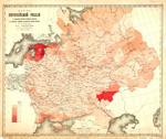 |
Карта европейской Россіи, съ показаніемъ процента учившихся дѣвочекъ въ сельскихъ училищахъ къ населенію учебнаго возраста (отъ 7 до 14 лѣт включ.) по уѣздамъ, по свѣдѣніямъ за 20ое. марта 1880 года [Karta evropeiskoĭ Rossīi, s pokazanīem prot͡senta uchivshikhsi͡a di͡evochek v sel'skikh uchilishchakh k naselenīi͡u uchebnago vozrasta (ot 7 do 14 li͡et vkli͡uch.) po ui͡ezdam, po svi͡edi͡enii͡am za 20oe. marta 1880 goda] / составили м. редакторъ Центральнаго статистическаго комитета А.В. Дубровскій и картографъ комитета А.Н. Петровскій [sostavili M. redaktor T͡Sentral'nago statisticheskago komiteta A.V. Dubrovskīĭ i kartograf komiteta A.N. Petrovskīĭ]. | School children--Russia, Western--Maps. Education--Russia, Western--Maps. |
Scale [1:16,800,000]. В С[анктъ] петербургѣ [V S[ankt] Peterburgi͡e] : КартограФическое заведеніе А. Ильина, [Kartograficheskoe zavedenīe A. Il'ina], [1880?]. 1 map : col. ; 60 x 71 cm. |
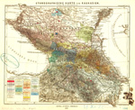 |
Ethnographische Karte von Kaukasien / von N. v. Seidlitz ; auf Petermanns Karte v. Ost-Europa gez. v. W.H. Fritzsche. | Ethnology--Caucasus--Maps. | Scale [ca. 1:3,500,000]. Gotha : Justus Perthes, 1880. 1 map : col. ; 27 x 31 cm. |
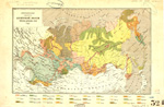 |
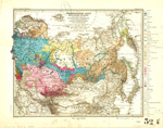
ЭтнограФическая карта Азіятской Россіи, Туркестана, и киргизских степей [Ėtnograficheskai͡a karta Azīi͡atskoĭ Rossīi, Turkestana, i kirgizskikh stepeĭ]. | Ethnology--Asiatic Russia--Maps. | Scale 1:16,500,000. [Saint Petersburg] : КартограФическое заведеніе А. Ильина [Kartograficheskoe zavedenīe A. Il'ina], [188-?]. 1 map : col. ; 27 x 44 cm. |
 |
Statistische Karten von Ungarn auf Grund der Volkszählungsdaten vom Jahre 1880/1 / entworfen und gezeichnet von Ign. Hátsek, Cartografen im k. ung. statist. Landesbureau ; B.H. red. | Ethnology--Hungary--Maps. | Scales differ. Gotha : Justus Perthes, 1882. 13 maps on 1 sheet : col. ; 16 x 24 cm. or smaller, on sheet 42 x 56 cm. |
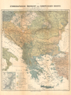 |
Ethnographische Übersicht des europäischen Orients / zusammengestellt von H. Kiepert. | Ethnology--Balkan Peninsula--Maps. | Scale [ca. 1:3,000,000]. Berlin : Verlag von D. Reimer, [1882?]. 1 map : col. ; 52 x 44 cm. |
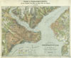 |
Plan von Constantinopel mit den Vorstädten, dem Hafen, und einem Theile des Bosporus / aufgenommen und gezeichnet von C. Stolpe nach den zeitherigen Veränderungen berichtigt bis zum Jahre 1882 = Plan de Constantinople avec ses faubourgs, le port et une partie du Bosphore / levé et dessiné par C. Stolpe, verifié d'après les changements les plus récents jusqu'en 1882 | Istanbul (Turkey)--Maps. Ethnology--Turkey--Istanbul--Maps. |
Scale 1:15,000. Constantinopel : Verlag von Lorentz & Keil, 1882. 1 map : col. ; 69 x 52 cm. |
 |
Ethnographische Karte von Guatemala / [Otto Stoll]. | Ethnology--Guatemala--Maps. | Scale 1:1,500,000. Zürich : Lith. Orell Füssli & Co., [1884]. 1 map : col. ; 34 x 37 cm. |
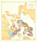 |
The Eskimo tribes of north-east America / by F. Boas. | Eskimos--Canada, Northern--Maps. Eskimos--Population--Maps. |
Scale not given. [Washington? : Government Printing Office?, 1885?]. 1 map : col. ; 52 x 47 cm. |
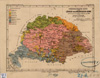 |
Ethnographische Karte der Länder der Ungarischen Krone / auf Grund der Volkszählung von 1880 von Ignaz Hátsek, Königl. ung. Kartograph ; red. v. B. Hassenstein ; aut. v. C. Schmidt. | Ethnology--Hungary--Maps. | Scale 1:4,000,000. Gotha : Justus Perthes, 1885. 1 map : col. ; 17 x 23 cm. |
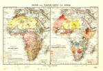 |
Kultur- und Staaten-Karte von Afrika / von Fr. Ratzel. | Ethnology--Africa--Maps. Africa--Administrative and political divisions--Maps. |
Scale 1:54,000,000. Gotha : Justua Perthes, 1885. 2 maps on 1 sheet : col. ; sheet 27 x 40 cm. |
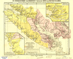 |
Die Indianerstämme von Vancouver Id. und an der Küste von Britisch-Columbia / nach eigenen Forschungen gezeichnet von Franz Boas ; red. v. B. Hassenstein ; aut. v. C. Schmidt. | Indians of North America--British Columbia--Maps. | Scale 1:2,000,000. Gotha : Justus Perthes, 1887. 1 map : col. ; 19 x 25 cm., on sheet 22 x 28 cm. |
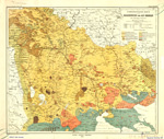 |
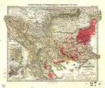
Ethnographische Karte von Makedonien und Alt-Serbien / von Spiridion Gopcevic. | Ethnology--Macedonia (Republic)--Maps. Ethnology--Greece--Macedonia--Maps. |
Scale 1:850,000. Gotha : Justus Perthes, 1889. 1 map : col. ; 41 x 49 cm. |
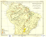 |
Ethnographische Karte von Brasilien / von Paul Ehrenreich ; red. v. B. Hassenstein ; aut. v. C. Schmidt. | Ethnology--Brazil--Maps. | Scale 1:20,000,000. Gotha : Justus Perthes, 1891. 1 map :col. ; 25 x 31 cm. |
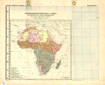 |
Ethnographische Übersicht von Afrika mit Berücksichtigung v. Kultur- u. Eingebornen-Staaten : nach Cust-Ravenstein u. Ratzel / entworfen v. H. Habenicht ; gez. v. C. Barich. 3 Aufl. | Ethnology--Africa--Maps. | Scale 1:25,000,000. Gotha : [Justus Perthes], 1892. 1 map : col., ; 39 x 40 cm. |
 |
Karte der Verbreitung der Sprachen in Südost-Mexico und British Honduras um's Jahr 1894 / von Karl Sapper. | Mexico--Languages--Maps. Belize--Languages--Maps. |
Scale 1:4,000,000. Gotha : Justus Perthes, 1895. 1 map : col. ; 29 x 38 cm. |
 |
Fremde Volksstämme im deutschen Reiche verglichen mit der Verteilung der christlichen Hauptbekenntnisse : auf Grund der neuesten amtlichen u. ausseramtlichen Aufnahmen gemeindeweise / bearbeitet von Paul Langhans ; auf Vogels Karte des deutschen Reichs in Stielers Hand-Atlas. | Ethnology--Germany--Maps. Ethnology--Poland--Maps. |
Scale 1:1,500,000. Gotha : Justus Perthes, 1895. 1 map : col. ; 48 x 42 cm. |
 |
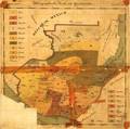
Nationalities map no. 1[-4], Polk St. to Twelfth ... Chicago. | Ethnology--Illinois--Chicago--Maps. Near West Side (Chicago, Ill.)--Maps. |
Scale [ca. 1:1,865]. New York : Thomas Y. Crowell & Co., 1895. 4 maps on 1 sheet : col. ; sheet 36 x 112 cm. |
 |
Verbreitung der Deutschen in den Ländern der ungarischen Krone : nebst Anschluss an die benachbarten oesterreichischen Länder / auf Grund der Sprachenzählung von 1890 gemeindeweise bearbeitet von Paul Langhans. | Ethnology--Hungary--Maps. | Scale 1:1,500,000. Gotha : Justus Perthes, 1896.1 map : col. ; 42 x 56 cm. |
 |
Die Thätigkeit der Ansiedelungs-Kommission für die Provinzen Westpreussen und Posen, 1886-1896 / auf Grund amtlicher Angaben entworfen von Paul Langhans ; auf Vogels Karte des Deutschen Reiches in 1:5000. | Ethnology--Poland--Prussia, West--Maps. | Scale 1:500,000. Gotha : Justus Perthes, 1896. 1 map : col. ; 60 x 41 cm. |
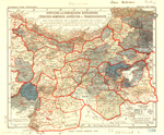 |
Verteilung der armenischen Bevölkerung in Türkisch-Armenien, Kurdistan, u. Transkaukasien : nach Cuinet, Selenoy, und v. Seydlitz / entworfen von A. Supan ; B.H. del. | Armenians--Turkey--Maps. Armenians--Caucasus--Maps. Ethnology--Turkey--Maps. Ethnology--Caucasus--Maps. |
Scale 1:3,700,000. Gotha : Justus Perthes, 1896. 1 map : col. ; 21 x 25 cm. |
 |
Das khartwelische Sprachgebiet im südwestlichen Kaukasus / von Hugo Schuchardt ; red. v. B. Hassenstein. | Kartvelian languages--Maps. Ethnology--Caucasus--Maps. Caucasus--Languages--Maps. |
Scale 1:1,300,000. Gotha : Justus Perthes, 1897. 1 map : col. ; 26 x 42 cm. |
 |
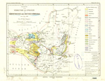
Carte ethnographique du Haut Nil / dressée par E. de Martonne ; gravé par A. Simon. | Ethnology--Africa--Maps. | Scale 1:6,000,000. [Paris] : Armand Colin & Cie., éditeurs, 1897. 1 map : col. ; 36 x 32 cm. |
  |
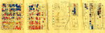
Der westafrikanische Kulturkreis / von L. Frobenius ; red. v. B. Hassenstein ; aut. v. C. Schmidt. | Human geography--Africa--Maps. Ethnology--Africa--Maps. |
Scale [ca. 1:50,000,000]. Gotha : Justus Perthes, 1897-1898. 20 maps on 2 sheets : col. ; maps 11 x 13 cm. each, sheets 28 x 69 cm. |
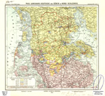 |
Deutsche und Dänen in Nord-Schleswig / Paul Langhans. | Ethnology--Germany--Schleswig-Holstein--Maps. Ethnology--Denmark--Syddanmark--Maps. |
Scale [ca. 1:500,000]. Gotha : Justus Perthes, 1899. 1 map : col. ; 25 x 33 cm. |
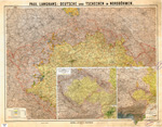 |
Deutsche und Tschechen in Nordböhmen / Paul Langhans. | Ethnology--Czech Republic--Bohemia--Maps. Ethnology--Europe, Central--Maps. |
Scale [ca. 1:500,000]. Gotha : Justus Perthes, 1899. 1 map : col. ; 61 x 77 cm. |
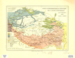 |
Carte ethnographique et politique de l'Asie centrale / par F. Grenard, 1899 ; J. Hansen. | Ethnology--China--Xinjiang Uygur Zizhiqu--Maps. Ethnology--China--Tibet--Maps. Ethnology--China--Qinghai Sheng--Maps. Ethnology--Asia, Central--Maps. |
Scale 1:9,000,000. Paris : Ernest Leroux, [1899?]. 1 map : col. ; 23 x 33 cm. |
  |
Die Kulturformen Ozeanien's / von L. Frobenius ; red. v. B. Hassenstein. | Ethnology--Oceania--Maps. | Scale [ca. 1:10,000,000]. At equator. Gotha : Justus Perthes, 1900. 18 maps on 2 sheets : col. ; maps 13 x 17 cm. each, sheets 43 x 53 cm. |

