Late 19th- and Early 20th-Century European City-Planning Maps
Click on the links below to access scans of some of the late 19th- and early 20th-century European city-planning maps that are held at the University of Chicago Library's Map Collection.
The maps take quite different approaches to the subject. Some are maps of actual plans for the future, not all of which (for example those of Cabourg and Moscow) were actually carried out. Others show land use at the moment the maps were made. Taken together, the maps support the general notion that government played a more central role in determining urban form during the latter part of the 19th- and early part of the 20th-century in Europe than in the United States. Note, for example, the plans for new housing documented in the maps of Rome that date from the 1880s. It was not until the construction of the first housing projects in the 1930s that American governments got into the housing business. Note also the elaborate land use plans from the 1920s. American cities during this period generally limited themselves to creating zoning codes. See the companion Web pages Planning Maps of Midwestern Cities in the 1920s and 1930s and Government Maps of Chicago in the 1920s, 1930s, and 1940s, and compare.
A few of the maps come from the collection of cartographic materials that was assembled by French geographer Emile Levasseur (1828-1911), bought by the old John Crerar Library in 1914, and acquired by the University of Chicago Library in 1930-1931. But most of the maps arrived as a result of a massive solicitation campaign conducted by the Map Collection’s staff just after its founding in 1929. An attempt was made to acquire then-contemporary urban maps from all over the world to support the University of Chicago’s distinguished urban-studies program. Few other libraries were collecting contemporary maps during this period, and most of the maps to which this page provides access seem not to be held anywhere else.
The maps were scanned on the Map Collection’s new HD Ultra i4250s Contex scanner at 400 dpi using NextImage software.
You can access these files in two different ways:
[1] Click on the thumbnails below to see the files in a program called Zoomify. Zoomify breaks the original tiff files into tiny jpegs, so you can zoom in and out and move around quickly and efficiently. Zoomify requires Flash and so won't work on many mobile phones.
[2] You can also see the files through Luna. Luna, like Zoomify, allows you to zoom in and out and to move around. It also allows download of jpeg versions of the files (click "Export"). To access the Luna files, click on the "Click here for Luna version" button.
The original tiff files are also available. E-mail from the "Questions about this page?" button below.
Downloaded files are freely available for personal or scholarly use. If you use the images in a publication, we expect that you will mention that the original maps--and the files--are from the University of Chicago Library's Map Collection.
Several people contributed to the construction of this Web page. John Jung of the University of Chicago Library's Digital Library Development Center did the necessary server preparation. Eric Green of the Map Collection did most of the scanning. Andrea Brown of the Map Collection handled most of the record manipulation. Sam Brown of the Map Collection diagnosed and alleviated several computer glitches. Bridget Madden of the University of Chicago's Visual Resources Center and Charles Blair of the Library's Digital Library Development Center developed a protocol in 2015 that allows access via Luna. And Bobby Butler, Emily Thompson, and Michael Weinrib of the Map Collection edited this page to point to the Luna versions.
The links below are listed below alphabetically by the English form of the city name.
Comments are welcome.
--CW
| Image | Title Information | Subject Headings | Description |
|---|---|---|---|
 |
Amsterdam : plan Zuider-Amstelkanaal. | City planning--Netherlands--Amsterdam--Maps. | Scale 1:5,000. [Amsterdam : Publieke Werken, 193-?]. 1 map : col. ; 24 x 57 cm. |
 |
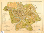
Kaart van Amsterdam 1:10000 / Dienst der Publieke Werken. | Land use--Netherlands--Amsterdam--Maps. | Scale 1:10,000. [Amsterdam] : Dienst der Publieke Werken, [1934]. 1 map : col. ; 101 x 100 cm. |
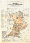 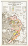 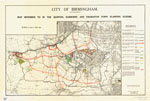 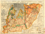 |
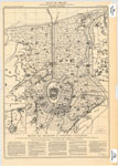
City of Birmingham : [planning maps]. Birmingham, North Yardley & Stechford town planning scheme, plan referred to -- East Birmingham town planning scheme, embodying amending scheme, 1918 -- Map referred to in the Quinton, Harborne, and Edgbaston town planning scheme -- Birmingham (south) town planning scheme, map referred to. Subjects: City planning -- England -- Birmingham |
City planning--England--Birmingham--Maps. Land use--England--Birmingham--Maps. |
Scale [1:10,560]. Birmingham : City Engineer & Surveyor's Office, 1921-[193-]. 4 maps : col. ; 68 x 94 cm. or less |
 |
Plan en projet d'un port de guerre et de commerce en eau profonde et d'une ville à Cabourg (Calvados) / dessiné & lith. par Ch. Lacoste. | City planning--France--Cabourg--Maps. Harbours--France--Cabourg--Maps. |
Scale 1:40,000. [Paris : Société de géographie], 1888. 1 map ; 31 x 25 cm. |
 |
Bebyggelsesarternes fordeling i København / Stadsingeniörens direktorat, Byplanafdelingen, marts 1932. | Land use--Denmark--Copenhagen--Maps. City planning--Denmark--Copenhagen--Maps. |
Scale 1:20,000. København : Geodætisk Institut, 1932. 1 map : col. ; 69 x 63 cm. |
 |
City of Coventry, the Coventry (no. 1) town planning scheme. Map no. 2 / E.H. Ford, city engineer. | City planning--England--Coventry--Maps. Land use--England--Coventry--Maps. |
Scale [1:15,840]. Westminster : Cook, Hammond, & Kell, Ltd., [1933?]. 1 map : col. ; 123 x 93 cm. |
 |
Gemeente 's-Gravenhage en naaste omgeving, schaal 1 a 20000 / Dienst der Stadsontwikkeling en Volkshuisvesting. | City planning--Netherlands--Hague--Maps. Land use--Netherlands--Hague--Maps. |
Scale 1:20,000. 's-Gravenhage : J. Smulders & Co., 1932. 1 map : col. ; 48 x 67 cm. |
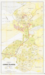 |
Karta öfver Lidingö villastad. | Lidingö (Sweden)--Maps City planning--Sweden--Lidingö--Maps. |
Scale 1:4,000. [Stockholm?] : Generalstabens litografiska anstalt, [between 1920 and 1929?]. 1 map : col. ; 83 x 48 cm. |
  |
Parochial plan of the City of London, shewing property removed for public works within the last 10 years and property at the present time scheduled for removal. | Ecclesiastical geography--England--London--Maps. City planning--England--London--Maps. City of London (England)--Maps. |
Scale [ca. 1:2,650]. London : John B. Day, [1870]. 1 map on 2 sheets : col. ; 64 x 116 cm. |
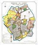 |
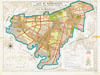
Borough of Ilford, town planning scheme, 1933 / L.E.J. Reynolds, borough engineer & surveyor. | City planning--England--London--Maps. Land use--England--London--Maps. Ilford (London, England)--Maps. |
Scale [1:10,560]. London : Sir Joseph Causton & Sons, Lithographers, [1933]. 1 map : col. ; 82 x 68 cm. |
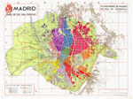 |
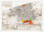
Madrid, plano de sus vias públicas / Artes Gráficas Municipales. | Madrid (Spain)--Maps. | Scale [ca. 1:14,000]. [Madrid] : Ayuntamento de Madrid, Sección de Estadística, 1934. 1 map : col. ; 75 x 100 cm. |
 |
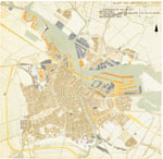
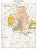
Entwicklungsplan für die Stadt Magdeburg und ihr Einflussgebiet / Entwurf, Stadterweiterungsamt Magdeburg, 1931. | City planning--Germany--Magdeburg--Maps. Land use--Germany--Magdeburg--Maps. |
Scale 1:50,000. [Merseburg : Verlag der Landesplanung für den Engeren Mitteldeutschen Industriebezirk, 1932]. 1 map : col. ; 36 x 52 cm. |
 |
City of Manchester, Manchester town planning scheme "B," 1920 / John Luke, city surveyor. | City planning--England--Manchester--Maps. | Scale [1:10,560]. [Manchester : Town Planning Special Committee, 1920?]. 1 map : col. ; 73 x 95 cm. |
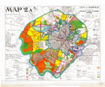
| Manchester & district regional scheme / Reginald Bruce. | City planning--England--Manchester--Maps. Regional planning--England--Manchester Region--Maps. Land use--England--Manchester--Maps. Land use--England--Manchester Region--Maps. |
Scale [ca. 1:25,000]. [Manchester, England? : Manchester and District Joint Town Planning Advisory Committee?, 192-?]. 1 map on 12 sheets : col. ; sheets 72 x 104 cm. | |
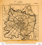 |
Схема планировки города Москвы [Skhema planirovki goroda Moskvy]. | City planning--Russia (Federation)--Moscow--Maps. | Scale [ca. 1:15,000]. Москва [Moskva] : Тип. изд-ва "Дер Эмес" [Tip. izd-va "Der Ėmes"], [1923?]. 1 map ; 24 x 27 cm. |
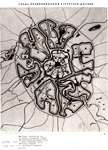 |
Схема планировочной структуры Москвы [Skhema planirovochnoĭ struktury Moskvy]. | City planning--Russia (Federation)--Moscow--Maps. | Scale not given. [Moscow? : s.n., ca. 1930?]. 1 map ; 23 x 21 cm. |
 |
City of Norwich, Norwich town planning scheme, Town Planning Act, 1925 / J.S. Bullough, city engineer & surveyor ; W.J. Taylor, town planning officer. | City planning--England--Norwich--Maps. Land use--England--Norwich--Maps. |
Scale [1:10,560]. Norwich : Town Planning Dept., 1930. 1 map : col. ; 72 x 92 cm. |
 |
Plan de l'Avenue de l'Opéra / gravé par Marboutin. | Quartier de l'Opéra (Paris, France)--Maps. City planning--France--Paris--History--Maps. |
Scale 1:2,000. [Paris] : A. Lassailly, [187-?]. 1 map : col. ; 9 x 48 cm. |
    |
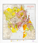
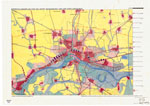
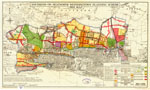
Carte du département de la Seine à l'échelle du 1/20.000e., indiquant la répartition des habitations, industries, culture, espaces libres (revisée d'après une enquête faite en 1934) / gravé chez L. Wuhrer. | Land use--France--Seine--Maps. Land use--France--Paris Metropolitan Area--Maps. |
Scale 1:20,000. [Paris] : Préfecture du département de la Seine, 1934. 1 map on 4 sheets : col. ; sheets 77 x 83 cm |
  |
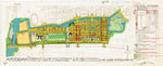
Ville de Reims, plan définitif d'aménagement. | City planning--France--Reims--Maps. Land use--France--Reims--Maps. Industries--France--Reims--Maps. |
Scale 1:5,000. [France : publisher not identified, 1934]. 1 map : photocopy, hand col. ; 124 x 132 cm. |
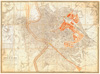 |
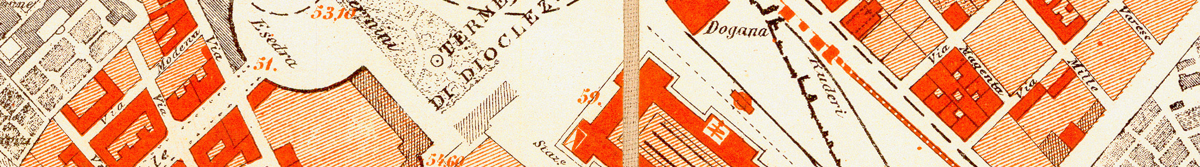
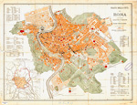
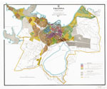
Pianta della città di Roma : con l'indicazione dei progetti dei principali lavori della città e del Tevere approvati per l'esecuzione / la presente pianta, eseguita per conto della Direzione di statistica, venne derivata dal rame inciso di A. Fornari, quindi corretta ed aggiornata per le nuove costruzioni sino all'anno 1880. | Rome (Italy)--Maps. City planning--Italy--Rome--Maps. |
Scale 1:7,680. Roma : Stab. lit. Virano e Teano, 1880. 1 map : col. ; 63 x 86 cm. |
 |
Modern Rome, showing the municipal scheme for the enlargement of the city. | City planning--Italy--Rome--Maps. Rome (Italy)--Maps. |
Scale [ca. 1:19,200]. London : A. & C. Black, [1887?]. 1 map : col. ; 25 x 35 cm. |
 |
Pianta della città di Roma : colle più recenti aggiunte e varianti al piano regolatore / M.G. aut. | City planning--Italy--Rome--Maps. Rome (Italy)--Maps. |
Scale 1:10,000. Roma : Cerroni e Solaro editori, 1887. 1 map : col. ; 49 x 65 cm. |
 |
Southend-on-Sea (north western), town planning scheme, 1933 map / Robt. H. Dyer, borough engineer. | City planning--England--Southend-on-Sea--Maps. Land use--England--Southend-on-Sea--Maps. |
Scale [1:10,560]. Southend-on-Sea : Borough Engineer's Office, 1934. 1 map : col. ; 48 x 81 cm. |
 |
Karta över Stockholm angivande stadsdelsindelning och stadsplanelagda områden, sammanställd år 1928. | City planning--Sweden--Stockholm--Maps. Stockholm Region (Sweden)--Maps. |
Scale 1:25,000. [Stockholm] : Statens reproduktionsanstalt, 1928. 1 map : col. ; 65 x 82 cm. |
 |
Tallinna linna plaan : kuulub riigi teataja Nr. 59 1932 a. avaldatud Tallinna linna ehitusemääruse juure = appendix to the metropolitan buildings bye-law 1932. | Zoning--Estonia--Tallinn--Maps. City planning--Estonia--Tallinn--Maps. |
Scale [ca. 1:15,400]. [Tallinn] : Riigi trükikoda, [1932?]. 1 map : col. ; 74 x 90 cm. |
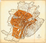 |
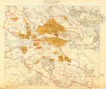
Pianta di Torino : coll'indicazione dei due piani regolatori e di ampliamento rispettivamente della zona piana (vigente per legge 5 aprile 1908 e R. decreto 15 gennaio 1920) e della zona collinare (vigente per decreto luogot. 10 marzo 1918) colle varianti approvate successivamente sino a marzo 1923) / compilata dal Servizio tecnico dei Lavori pubblici. | Turin (Italy)--Maps. City planning--Italy--Turin--Maps. |
Scale 1:20,000. Torino : Lit. Doyen di L. Simondetti, [1923?]. 1 map : col. ; 77 x 80 cm. |
        |
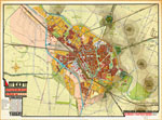
Pianta di Torino : coll'indicazione dei due piani regolatori e di ampliamento rispettivamente della zona piana (vigente per legge 5 aprile 1908 e R. decreto 15 gennaio 1920) e della zona collinare (vigente per decreto luog. 10 marzo 1918) aggiornati colle varianti approvate successivamente sino a marzo 1926 / compilata dalla Divisione III dell'Ufficio municipale dei Lavori pubblici. | Turin (Italy)--Maps. City planning--Italy--Turin--Maps. |
Scale 1:5,000. Torino : Lit. Doyen di L. Simondetti, [1926?]. 1 map on 8 sheets : col. ; 252 x 208 cm., sheets 75 x 122 cm. |
 |
Utrecht : uitbreidingsplan / [vervaardigd onder toezicht van] de directeur van gemeentewerken, L.N. Holsboer, de adviseur v/h plan, Dr. H.P. Berlage. | Utrecht (Netherlands)--Maps. City planning--Netherlands--Utrecht--Maps. |
Scale 1:10,000. [Utrecht : s.n.], 1924. 1 map : col. ; 76 x 104 cm. |

