The Maps of Heinrich Kiepert
The Maps of Heinrich Kiepert
Geographer Heinrich Kiepert (1818-1899) is generally reckoned one of the more important scholarly cartographers of the second half of the 19th century. This Web page provides access to some Kiepert maps held at the University of Chicago Library's Map Collection.
Kiepert acquired one of his interests—the historical geography of the classical world—in his student days at the University of Berlin, where he worked with Carl Ritter (1779-1859). Ritter and Kiepert produced what appears to have been one of the first modern atlases of the ancient Greek world, Topographisch-historischer Atlas von Hellas und den hellenischen Colonien in 24 Blättern (1840-1846). Several additional compilations of maps of the classical world followed: Bibel-Atlas (1847); Historisch-geographischer Atlas der alten Welt (1848); Atlas antiquus (1854); Formae orbis antiqui (1893); and Formae urbis Romae antiquae (1896). Many of these works were reissued in numerous editions, including translations.
Another major interest was the Ottoman Empire, where Kiepert travelled numerous times, gathering enough data to produce several major maps of the Ottoman world between the 1840s and 1890s.
Kiepert was also responsible for some of the first detailed ethnic maps of Germany, Austria-Hungary, and the Balkan Peninsula. In the course of many years, he compiled maps of much of the rest of the world as well, in addition to cartographic materials for schools.
Kiepert was head of the Geographisches Institut in Weimar between 1845 and 1852 and professor at the University of Berlin from 1852. He maintained a long association with the publisher Dietrich Reimer. Many later editions of Kiepert's maps were updated by his son, Richard Kiepert (1846-1915).
Kiepert's maps are almost invariably clear and easy to read, and they are as accurate as the scholarship of the day permitted. His maps of the historical geography of the classical world have inevitably come to seem a bit old-fashioned in light of later research, but his maps of the Ottoman Empire and surrounding countries remain extraordinarily valuable records of conditions in the period when they were compiled.
Only about a tenth of the Library's Kiepert holdings are linked on this site. The University of Chicago Library's catalog has a complete list. The companion Web page, 19th-Century Maps of the Middle East, North Africa, and Central Asia, provides access to some additional Kiepert maps. In addition, the David Rumsey Website has scans of some of the maps produced by Kiepert during his years at the Geographisches Institut in Weimar.
For further information on Kiepert, see: Antike Welten, neue Regionen : Heinrich Kiepert, 1818-1899, edited by Lothar Zögner (Berlin : Kiepert, 1999).
Virtually all of the maps linked below are part of a collection of maps assembled by the French geographer Emile Levasseur (1828-1911) that was bought in 1914 by the old John Crerar Library and acquired in 1930-1931 by the University of Chicago Library. The collection consists largely of scholarly maps of the 19th and very early 20th centuries. It includes maps that were issued as sheet maps; wall maps for schools; maps from academic journals; and atlases. It also includes a scattering of earlier material.
The maps were scanned at 400 dpi using NextImage software and were saved as tiff files
You can access these files in two different ways:
[1] Click on the thumbnails below to see the files in a program called Zoomify. Zoomify breaks the original tiff files into tiny jpegs, so you can zoom in and out and move around quickly and efficiently. Zoomify requires Flash and so won't work on many mobile phones.
[2] You can also see the files through Luna. Luna, like Zoomify, allows you to zoom in and out and to move around. It also allows download of jpeg versions of the files (click "Export"). To access the Luna files, click on the "Click here for Luna version" button.
The original tiff files are also available. E-mail from the "Questions about this page?" button below.
Downloaded files are freely available for personal or scholarly use. If you use the images in a publication, we expect that you will mention that the original maps--and the files--are from the University of Chicago Library's Map Collection.
Several people contributed to the construction of this Web site. The Digital Media Laboratory let Map Collection staff use its Contex scanner, and Dale Mertes of the Digital Media Lab provided an enormous amount of assistance. Joost Dupon of the Map Collection played a major role in selecting the material. He also did most of the scanning and image preparation. Bridget Madden of the University of Chicago's Visual Resources Center and Charles Blair of the Library's Digital Library Development Center developed a protocol in 2015 that allows access via Luna. And Bobby Butler of the Map Collection did some light file editing before the conversion and then edited the Map Collection pages to point to the Luna pages.
Comments are welcome.
--CW
| Image | Title Information | Subject Headings | Description |
|---|---|---|---|
 |
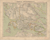
Die Indusländer nebst Afghanistan und Süd-Turkistan : zur Übersicht der Kriegsbegebenheiten, nach englischen und russischen Karten und Reiseberichten / bearbeitet von H. Kiepert ; gez. v. H. Kiepert ; gest. v. G. Haubold. | Pakistan--Maps. Afghanistan--Maps. Indus River Valley--Maps. |
Scale 1:4,000,000. Weimar : Verlag des Geograph. Instituts, 1849. 1 map : col. ; 51 x 42 cm. |
 |
General-Karte von der europäischen Türkei : nach allen vorhandenen Originalkarten und itinerarischen Hülfsmitteln / bearbeitet und gezeichnet von Heinrich Kiepert ; Schrift gestochen von W.u.C. Kratz in Weimar ; Terrain radirt von C. Ohmann in Berlin. | Balkan Peninsula--Maps. Thrace, Eastern (Turkey)--Maps. |
Scale 1:1,000,000. Berlin : In Commission bei Dietrich Reimer, 1853. 1 map : col. ; 81 x 122 cm. |
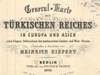 |
General Karte des Türkischen Reiches in Europa und Asien nebst Ungarn, Südrussland, den kaukasischen Ländern und West-Persien / entworten u. bearbeitet von Heinrich Kiepert. | Turkey--Maps. Thrace, Eastern (Turkey)--Maps. Balkan Peninsula--Maps. |
Scale 1:3,000,000. Berlin : Verlag von Dietrich Reimer, 1855. 1 map on 4 sheets : col. ; 88 x 123 cm., sheets 43 x 59 cm. |
 |
A new map of Central-America / drawn with the help of all recent surveys and other itinerary materials hitherto published by H. Kiepert ; engraved on stone by Ed. Kolitz = H. Kiepert's neue Karte von Mittel-America. | Central America--Maps. | Scale 1:2,000,000. Berlin : D. Reimer, 1858. 1 map on 4 sheets : col. ; 89 x 110 cm., sheets 60 x 61 cm. |
 |
Hannover, Braunschweig, Oldenburg, und die Hansestädte / gezeichnet v. H. Kiepert u. C. Ohmann ; gest. v. C. Kratz III. | Lower Saxony (Germany)--Maps. | Scale 1:600,000. Weimar : Geographisches Inst., [186-?]. 1 map : col. ; 52 x 62 cm. |
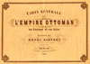 |
Carte générale de l'Empire Ottoman en Europe et en Asie / dressée par Henri Kiepert. | Turkey--Maps. Middle East--Maps. |
Scale 1:3,000,000. Berlin : D. Reimer, 1867. 1 map on 4 sheets : col. ; 102 x 134 cm., sheets 51 x 67 cm. |
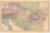 |
Völker- und Sprachen-Karte von Österreich und den Unter-Donau-Ländern / zusammengestellt von H. Kiepert. | Ethnology--Austria--Maps. Ethnology--Hungary--Maps. Ethnology--Balkan Peninsula--Maps. |
Scale 1:3,000,000. Berlin : D. Reimer, 1869. 1 map : col. ; 36 x 58 cm. |
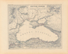 |
Pontische Colonien. | Black Sea Region--Historical geography--Maps. | Scale 1:3,000,000. Berlin : Nicolaische Verlagsbuchhandlung, 1867. 1 map : col. ; 36 x 45 cm. From: Neuer Atlas von Hellas und den hellenischen Colonien in 15 Blätter / bearbeitet von H. Kiepert. |
 |
Karte des Russischen Reichs in Europa in 6 Blättern / bearbeitet von H. Kiepert. 3. verbesserte Aufl. | Russia--Maps. | Scale 1:3,000,000. Berlin : Dietrich Reimer, 1872. 1 map on 6 sheets : col. ; 133 x 116 cm., sheets 52 x 66 cm. |
 |
Völker[-] und Sprachen-Karte von Deutschland und den Nachbarländern / zusammengestellt von H. Kiepert. | Ethnology--Germany--Maps. Ethnology--Poland--Maps. Ethnology--Europe, Central--Maps. |
Scale 1:3,000,000. Berlin : D. Reimer, [1872]. 1 map : col. ; 42 x 54 cm. |
 |
Special-Karte des deutschen Reichslandes Elsass-Lothringen : im Auftrage des kaiserlichen Ober-Präsidiums zu Strassburg / nach amtlichen Quellen bearbeitet von Heinrich Kiepert ; Schriftst. v. C. Bischoff ; Terrainst. v. J. Sulzer. | Alsace (France)--Maps. Lorraine (france)--Maps. |
Scale 1:250,000. Berlin : Verlag von Dietrich Reimer, 1879. 1 map on 4 sheets : col. ; 98 x 82 cm., sheets 61 x 50 cm. |
 |
Carte de l'Épire et de la Thessalie / dressée par H. Kiepert. Nouvelle éd. corrigée en 1880. | Epirus (Greece and Albania)--Maps. Thessaly (Greece)--Maps. |
Scale 1:500,000. Berlin : Chez D. Reimer, 1880. 1 map on 2 sheets : col. ; 44 x 88 cm., sheets 58 x 50 cm. Accompanied by explanatory note about proposed revisions of Greco-Turkish political borders (1878-1880), on sheet 29 x 22 cm. |
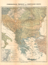 |
Ethnographische Übersicht des europäischen Orients / zusammengestellt von H. Kiepert. | Ethnology--Balkan Peninsula--Maps. | Scale [ca. 1:3,000,000]. Berlin : Verlag von D. Reimer, [1882?]. 1 map : col. ; 52 x 44 cm. |
 |
Graecia septentrionalis / Henrici Kiepert ; lith. J. & R. Sulzer. | Central Greece and Euboea (Greece)--Historical geography--Maps. | Scale 1:800,000. Berolini : Libraria geographica Diterici Reimer, 1894. 1 map : col. ; 43 x 55 cm. Probably removed from: Formae orbis antiqui : Karten mit kritischem Text und Quellenangabe zu jeder Karte. Berlin : Dietrich Reimer, 1894-1914. |
 |
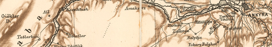
Specialkarte vom westlichen Kleinasien : nach seinen eigenen Reisen und anderen grösstenteils noch unveröffentlichten Routenaufnahmen bearbeitet / von Heinrich Kiepert = Carte de la partie occidentale de l 'Asie mineure / dressée par Henri Kiepert d'après ses propres observations et d'autres levées pour la plupart inédites = Map of the western part of Asia Minor / drawn by Henry Kiepert from his own researches and other surveys mostly unpublished. | Turkey--Maps. | Scale 1:250,000. Berlin : Verlag von Dietrich Reimer, 1890-1892. 16 maps : col. ; each 50 x 61 cm. or less. |
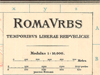 |
Roma vrbs / H. Kiepert et Ch. Hvelsen del. ; Ricardvs Kiepert recognovit. | Rome (Italy)--Historical geography--Maps. | Scale 1:10,000. Berolini : Apvd D. Reimer (E. Vohsen), [1912]. 3 maps : col. ; each 55 x 60 cm. |

