Map Collection news
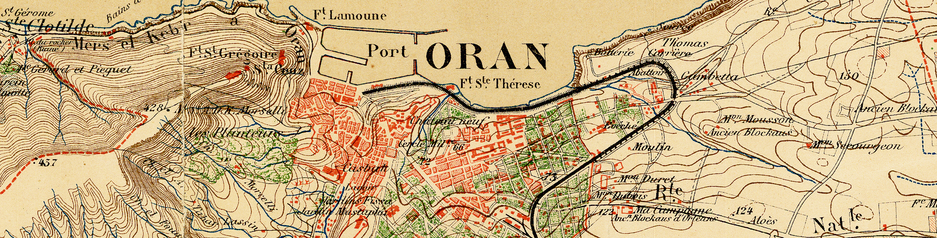
New Web page devoted to 19th-century maps of the Middle East, North Africa, and Central Asia
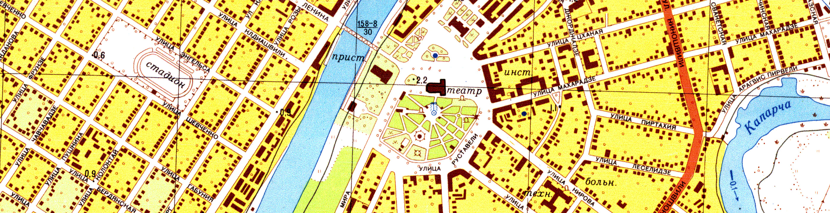
The Map Collection has recently added a new Web page that provides access to scans of some of its holdings of 19th-century maps of the Middle East, Central Asia, and North Africa. Both regional and urban maps, and both general and thematic maps are included. There are maps compiled by military topographic mapping agencies, maps from scholarly journals, and commercial maps. Only a small number of the maps appear to be held by other North American libraries.
--CW, February 2016
***
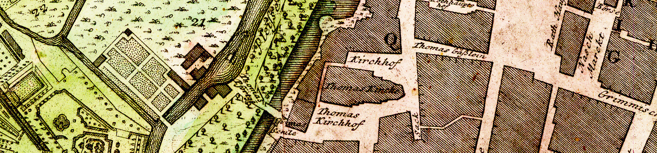
New Web page devoted to 18th-century maps of Central Europe
The Map Collection recently added a new Web page that provides access to electronic versions of most of its holdings of 18th-century maps of Central Europe. The page differs from other Map Collection compilations of scanned maps in that it includes many more maps; the maps are all older than those on the other pages; and the links for the moment are only to Luna (rather than to Zoomify and Luna). The page provides access to maps that cover all or parts of Germany, Austria, Hungary, the Czech Republic, Poland, and the Balkan Peninsula. There are also numerous city maps including maps of Vienna, Berlin, Leipzig, Prague, and Wrocław. In addition, there are thematic maps covering such subjects as the postal service, economic actvity, and battles in the Seven Years' War. Few of the maps appear to be held by other North American libraries.
--CW, September 2015
***
Downloading of scanned maps now possible
Map Collection staff started putting scanned maps online in 2003. Since then we've created fifteen pages of scanned maps, in the form of more or less permanent exhibits of related materials (click here for a list). The scanned maps on the Map Collection Website have been a modest hit. Something like 500 a day are looked at. That’s about as many maps as live users ask for in the course of approximately six weeks.
Until now, Zoomify has been used to share the maps. Zoomify breaks up the original tiff files into a very large number of tiny jpegs at several different scales. It allows one to zoom in and out and move around quite rapidly. Zoomify does not allow download of files. This seemed appropriate to many people in the Library some years back. Library servers would have had trouble with the large files. Also, there was a feeling that sharing holdings with the general public should not be done too casually. Times have changed. Servers now have more bandwidth, and there is less worry these days about sharing files. In addition, there is no doubt that patrons have grown to expect that libraries would be more generous. There have been frequent requests for the tiff files.
Over the last year and a half Charles Blair of the Digital Library Development Center and Bridget Madden of the Art History Department's Visual Resources Center have been putting together a protocol that allows downloading of the map files via Luna (I’m very grateful), and Map Collection staff have just added links to Luna versions of the files on the Map Collection Web pages. Access via Zoomify has been retained as it’s clearly pleased many users.
--CW, July 2015, updated August 2015
***
Better access to early nautical charts
The Map Collection generally catalogs maps at the set level. Access to individual sheets in topographic map sets is through index maps, which are all marked with holdings (many of these are online). Access to individual sheets in sets of nautical charts is through index booklets from the publishing agencies. These booklets are generally no older than the 1920s. Unfortunately, in some cases, the arrangement of sheets changed between the time the maps were first published in the early- or mid-19th century and the date of publication of the index. Thus, there has typically been minimal access to older nautical charts.
Older nautical charts are often of particular interest. In the United States, Britain, and France the military agencies responsible for nautical charts were often active many years before corresponding civilian mapping agencies were created, and they all mapped land areas near coasts just as assiduously as they mapped undersea features and port facilities. The United States Coast Survey, for example, generally began systematic mapping of coastal areas in the 1830s, fifty years before the U.S. Geological Survey began to create topographic maps of the United States in a similarly systematic way. One result is that the best mid-19th-century maps of many coastal cities (for example, Boston and San Francisco) come from the Coast Survey, or (more often) its successor agency, the U.S. Coast and Geodetic Survey. Similarly, the British Admirality and the French Dépôt des cartes et plans de la marine were creating excellent maps of foreign coastal areas a hundred years before the G.S.G.S. and the Service géographique de l'Armée were established. Like the early U.S. nautical charts, 19th-century British and French charts, unlike commercial maps, sometimes show individual buildings and nearly always include meaningful survey dates.
Because early maps from all of these agencies are often not indexed in the booklets available at the Map Collection, Map Collection staff have started a project to create cataloging records for individual sheets. As of the summer of 2015, all 19th-century (and a scattering of early 20th-century) American, British, and French nautical charts are represented by separate records in the online catalog.
Access to the later, fully indexed charts (which generally have less information on land features) will continue for the moment to be at the set level only.
--CW, December 2014, updated July 2015
***
New Web page devoted to European city-planning maps
The Map Collection recently added a new Web page that provides access to some of the late 19th- and early 20th-century European city-planning maps in the Collection. Some are maps of actual plans for the future. Others show land use or zoning at the time the maps were compiled. There are maps for cities in both Western and Eastern Europe. Few of the maps appear to be held by any other library.
--CW, August 2014
***
New large-format scanner
The Map Collection has recently acquired a new Contex HD Ultra i4250s large-format roller scanner. The new scanner can scan flat objects, like maps, drawings, and posters, as wide as 42 inches at a resolution of up to 1200 dpi. It is much faster than the older Contex Crystal XL42 scanner that it replaces, and, unlike the older machine, it runs under Windows 7. The scanner was paid for through general Library funds (we are very grateful!).
The scanner is available to any Library user during the hours that the Map Collection is open, Monday to Friday, 12 to 5. Because the scanner is a sensitive and pricey machine, Map Collection staff will ask patrons to undergo a very brief training session before they are allowed to use it.
--CW, December 2013
***
80,000 cataloging records for cartographic materials
Map Collection staff added a record to WorldCat (OCLC) on August 23 2013 that turned out to be the University of Chicago's 80,000th WorldCat record for cartographic materials. No other university library has its holding symbol on more cartographic-materials records (although the Library of Congress has its on more than 300,000 records). Of the 80,000 records, more than 70,000 are for the sheet maps; the rest are for atlases. Perhaps a third are original records; the rest come from other libraries. The 80,000th record--OCLC 856655692--is a description of a reprint of a Soviet-era map of P'ot'i, Georgia.
Approximately 90% of the Map Collection's sheet-map holdings are now cataloged.
--CW, August 2013
***
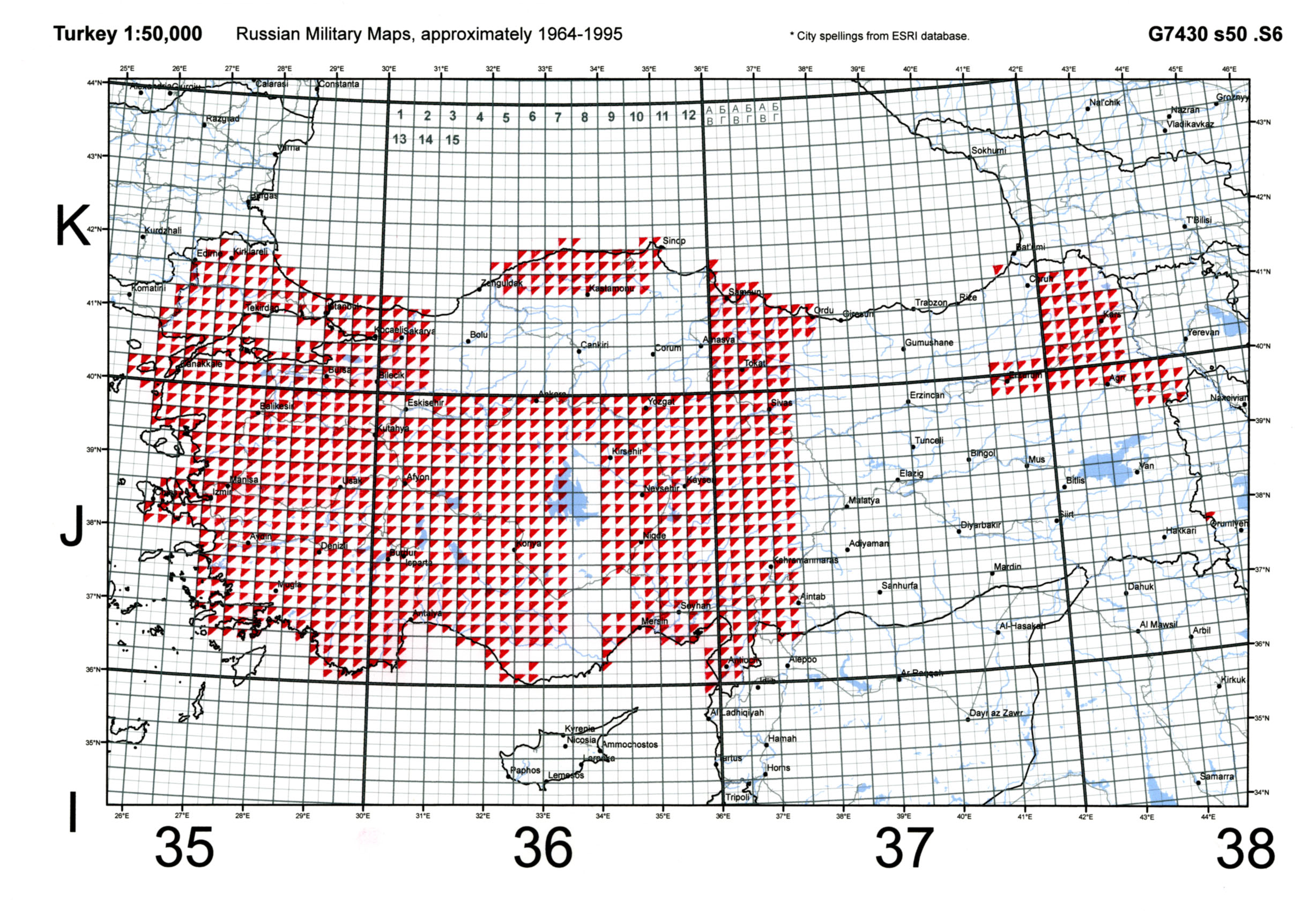
Map indexes online
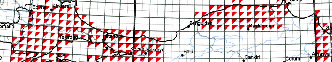
More than half the maps in most big university map libraries are individual sheets in topographic map sets. Cataloging records for these sets are notoriously unhelpful, because they contain no information about holdings. Most map libraries keep track of their holdings with paper graphical indexes. These indexes have traditionally been kept with the sets and have been accessible only to those able to visit.
Following the lead of several other libraries, the University of Chicago Map Collection began putting some of its indexes to sets of "topos" online in the spring of 2013. An example can be found by clicking here. Each rectangle on these maps corresponds to one sheet. The red triangles show sheets actually held. The online indexes are accessible through the cataloging records for the sets. We have also created a Web page that provides access to some of the available index maps.
--CW, July 2013
***
Captured Japanese maps processed
As a result of World War II, the American Army found itself in possession of hundreds of thousands of maps that had been prepared by German and Japanese military mapping services. These maps--along with maps compiled by the Army Map Service itself--were distributed to American (and some foreign) university libraries in the years after 1945. The maps from the Army Map Service and the German maps ended up forming a substantial part of the collections at many university map libraries, including that at the University of Chicago.
The German maps--often a little more polished than the maps from which they were derived--have been a particularly valuable resource for scholars ever since. They provide extraordinarily detailed coverge of much of Europe and the Middle East. It goes without saying that use of these maps does not imply endorsement of the actions of the government that compiled them.
The Japanese maps, never as numerous and not as widely distributed, have not proved as important, in part because they are much more difficult to deal with. They are in Japanese, so using them presents language problems. Many lack coordinates, so even identifying the areas being mapped can be challenge, a fact complicated by name changes in some countries. Also, the Japanese military agencies that produced the maps obviously did not have libraries in mind, and often gave what appear to be series of maps inconsistent names. Furthermore, the maps are of varying quality. Some are superb; others contain large white areas, implying that the maps' compilers had insufficient information to make a polished map.
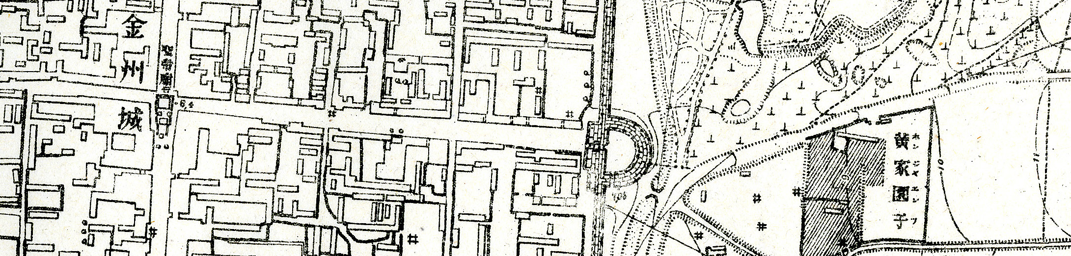
The University of Chicago Library apparently ranked high in the distribution lists for these maps and gradually added the majority of them to the Collection over the years. The maps of Chinese cities have proved particularly important to scholars. Most have a note saying that they are based on Chinese maps, but the Chinese originals are hard to come by. The maps preserve the original Chinese characters (occasionally supplemented with katakana pronunciations) and present an invaluable record of Chinese urbanism during the years when it was beginning to be affected by the modern world. Additional Japanese maps added to the Collection in earlier years include sets of topographic maps of Taiwan, Manchuria, the Russian Far East, and many Pacific islands.
Several thousand of the more difficult-to-deal-with Japanese maps had--rather embarrassingly--never been fully processed as of 2011. They had sat in boxes in the Map Collection for 60 years.
Thanks in large measure to the hard work of student assistant Naoko Takeuchi, the Map Collection began the task of processing these remaining sheets and adding them to the Collection in fall 2012. Among the materials that turned up was a nearly complete set of 1:50,000 maps of Korea in the 1920s and the 1930s. Maps of much of Eastern China at 1:50,000 or 1:100,000 in the same period were also added. There were also dozens of 1:10,000 maps of Korean cities, a scattering of material from Southeast Asia, and a very large number of detailed maps of Japan itself. We have been fortunate in having access to online indexes prepared by the University of California at Berkeley and the National Diet Library, but--partly because we seem to have numerous sheets not held anywhere else--we have ended up preparing many of the indexes for topographic map sets ourselves using ArcGIS. As these maps have been officially added to the Collection, cataloging records for them (all with kanji) have been added to the Library's online catalog. Locally prepared indexes for topographic map sets are in some (but not all) cases accessible through the cataloging records or in an index of indexes.
As of summer 2014, more than 98% of these maps have been fully processed.
--CW, June 2013, updated December 2013 and August 2014
***
Nokia-Siemens maps
Nokia Solutions and Networks (the former Nokia-Siemens Networks) of Arlington Heights, Illinois, has donated an extraordinary collection of more than 30,000 sheet maps to the University of Chicago Library.
The maps are mostly topographic maps. They show buildings and settlements, infrastructure, vegetation, hydrography, relief, and, in some cases, land use. Scales range from 1:5,000 to 1:500,000. The maps date from the 1950s to the 1990s.
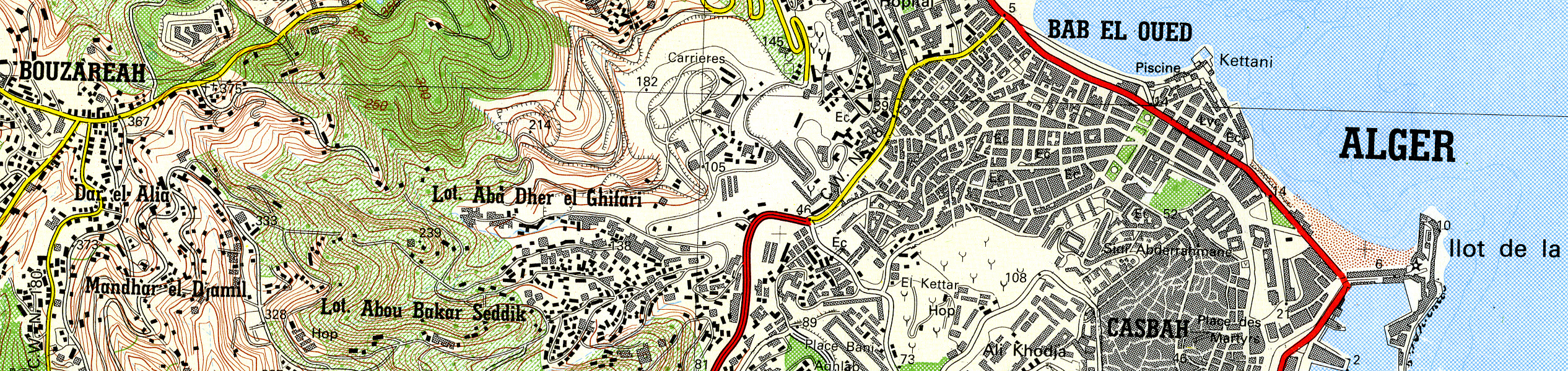
Many of the maps are from countries where topographic mapping is normally very difficult to acquire. The collection includes, for example, local 1:25,000 maps of most of South Korea, northern Algeria, and Java; local 1:50,000 maps of much or all of Jordan, Egypt, Pakistan, and the United Arab Emirates; Soviet 1:50,000 maps of all or part of Poland, Greece, Turkey, Georgia, Uzbekistan, and Belarus; and Soviet 1:100,000 maps of all or part of Libya and northern India. It would be essentially impossible to recreate this collection by purchases.
The maps were originally used mostly to site cellphone towers. They were collected by Motorola before its acquisition by Nokia-Siemens Networks. According to Malcolm Matthews of Nokia Solutions and Networks, the company began to use satellite imagery and GIS in the late 1990s rather than sheet maps. A decision was made in 2012 to offer the maps to local research libraries.
The collection is being shared with Northwestern University. Northwestern has taken most of the maps of sub-Saharan Africa and Latin America, and the University of Chicago Map Collection has taken most of the maps of North Africa and the Middle East, Europe, the former Soviet states, and South, Southeast, and East Asia.
With this donation, the University of Chicago Library Map Collection's holdings of sheet maps have reached 470,000. The Map Collection had been adding approximately 3,000 sheets per year over the last decade, so taking on more than 30,000 sheets at one time has presented a substantial challenge. A major shift to accommodate the new maps was necessary. Its chief component was the compression of U.S. Geological Survey topographic maps to create space in the Eastern Hemisphere cases. More than 300,000 maps were moved last winter to prepare for the Nokia acquisition.
Processing the maps has also been a major task. As of October 2013, all of the maps have been fully cataloged and indexed. In some cases the indexes appear online and are accessible from the cataloging records.
The maps have already found several users, among them an undergraduate writing a thesis on Amman, an archaeologist with a particular interest in the Dodecanese Islands, and a faculty member researching Burmese transportation.
--CW, April 2013, updated July and October 2013

