Browse by
| Collections | |||
|---|---|---|---|
| Collection Thumbnail | Title | Formats | Subjects |
|
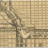
Government maps of Chicago in the 1920s, 1930s, and 1940s During the 1920s, 1930s, and 1940s, there was a slow growth in the planning role of municipal governments in many large American cities, including Chicago. Cartographic materials of various sorts were one of the byproducts of this growth. |
Formats Digital Maps |
Subjects American History Political Science Chicago and Illinois Maps Geography |
|
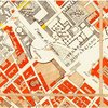
Late 19th- and Early 20th-Century European City-Planning Maps Late 19th- and early 20th-century European city-planning maps that are held at the University of Chicago Library's Map Collection. Some are maps of actual plans for the future, not all of which (for example those of Cabourg and Moscow) were actually carried out. |
Formats Digital Maps |
Subjects History Political Science Maps |

|
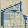
Planning Maps of Midwestern Cities in the 1920s and 1930s Government planning maps of Midwestern cities from the 1920s and 1930s. Most of the maps are zoning or land-use maps. |
Formats Digital Maps |
Subjects Political Science American History Maps Geography |
|
Social Scientists Map Chicago Geographer Chauncy Harris often argued that Chicago in the first half of the 20th century was the most studied city in the world. This claim is unprovable, but there were certainly an enormous number of scholarly studies of Chicago between the 1920s and the middle of the 20th century. Many of these included maps. |
Formats Digital Maps |
Subjects Sociology Political Science American History Chicago and Illinois Maps |