Planning Maps of Midwestern Cities in the 1920s and 1930s
|
|

Planning Maps of Midwestern Cities in the 1920s and 1930s
Click on the links below to access scans of some of the government planning maps of Midwestern cities from the 1920s and 1930s that are held at the University of Chicago Library's Map Collection. (For comparable maps of Chicago, see the companion Web page, Government Maps of Chicago in the 1920s, 1930s, and 1940s.)
Most of the maps are zoning or land-use maps. The relationship between zoning and land use in American cities is close but not simple. No one--at least before the era of large-scale "urban renewal"--would have proposed a zoning code for a settled neighborhood that involved a complete change in land use. Chicago's first land-use map was compiled explicitly to facilitate the writing of the city's first zoning ordinance. It is possible (but not provable) that most of the zoning of populated areas in the maps indexed below represents a radically simplified, idealized portrait of actual land use.
The kind of land use regulation shown in these maps came late to the United States, but it spread quickly in the years after New York's 1916 adoption of what was apparently the first American city-wide zoning code. Many, perhaps most, American cities--even small ones--promulgated similar laws over the next decade and a half*. A 1939 map shows that virtually all Minnesota cities had zoning laws by the end of the 1930s.
We have also included a few other kinds of planning maps: for example, a census-block map of Detroit; a parking-lot map of central Detroit; a street plan for Milwaukee; and a map of Milwaukee's Parklawn, one of the country's first housing projects.
Some of the larger cities portrayed in these maps have become notorious for their problems. Since the 1950s, Detroit and, to a lesser extent, a few other Midwestern cities have lost a substantial part of their population and housing stock. The maps indexed on this Web page predate this decline. The maps' compilers expected that the cities would continue to grow indefinitely--and that their central portions would become considerably denser.
We have included several maps whose compilers, publishers, and dates of production we do not know. We would be very grateful for information that would allow us to identify these publications with greater precision.
This page provides access only to a small proportion of the Midwestern urban planning maps that are held at the University of Chicago Map Collection. Additional maps (especially of smaller cities) are listed in the Library's on-line catalog under subject headings like "City planning--[state name]--[city name]--Maps," "Zoning--[state name]--[city name]--Maps," and "Land use--[state name]--[city name]--Maps." This approach should work for finding English-language records on WorldCat and in other North American libraries' catalogs as well.
The maps were scanned on a Contex Crystal XL42 scanner at 400 dpi using NextImage software.
You can access these files in two different ways:
[1] Click on the thumbnails below to see the files in a program called Zoomify. Zoomify breaks the original tiff files into tiny jpegs, so you can zoom in and out and move around quickly and efficiently. Zoomify requires Flash and so won't work on many mobile phones.
[2] You can also see the files through Luna. Luna, like Zoomify, allows you to zoom in and out and to move around. It also allows download of jpeg versions of the files (click "Export"). To access the Luna files, click on the "Click here for Luna version" button.
The original tiff files are also available. E-mail from the "Questions about this page?" button below.
Downloaded files are freely available for personal or scholarly use. If you use the images in a publication, we expect that you will mention that the original maps--and the files--are from the University of Chicago Library's Map Collection.
Several people contributed to the construction of this Web page. Joel Thomas of the Map Collection did essentially all the scanning, most of the record manipulation, and a modest amount of Photoshop editing. He also did some last-minute preservation work on a few of the sheets. The University of Chicago Library's Digital Library Development Center did the necessary server preparation. And former bibliographer Frank Conaway (and others) made useful editorial suggestions about this text. Bridget Madden of the University of Chicago's Visual Resources Center and Charles Blair of the Library's Digital Library Development Center developed a protocol in 2015 that allows access via Luna. And Bobby Butler, Emily Thompson, and Michael Weinrib of the Map Collection edited this page to point to the Luna versions.
The links below are listed alphabetically by city (or, in one case, state) name.
Comments are welcome.
--CW
| Image | Title Information | Subject Headings | Description |
|---|---|---|---|
 |
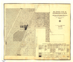
City of Bloomington, Ind. / H. Victor Carman, city civil engineer. | Land use--Indiana--Bloomington--Maps. | Scale [ca. 1:12,000]. [Bloomington] : Dept. of Engineering, [1927?]. 1 map : hand col. ; 73 x 51 cm. |
 |
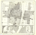
Official city plan map, Cincinnati, Ohio / City Planning Commission ; Technical Advisory Corporation, consulting engineers. | City planning--Ohio--Cincinnati--Maps. City planning--Ohio--Cincinnati Metropolitan Area--Maps. |
Scale 1:24,000. [New York] : Technical Advisory Corp., 1925. 1 map : col. ; 96 x 132 cm. |
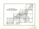 |
The building zone maps of the city of Cleveland. | Zoning--Ohio--Cleveland--Maps. | Scale [ca. 1:15,840]. [Cleveland] : City Plan Commission, [193-?]. 9 maps : col. ; on sheets 40 x 47 cm. or smaller. |
 |
Zoning map, city of Columbus, Ohio. | Zoning--Ohio--Columbus--Maps. | Scale [ca. 1:17,200]. [Columbus] : City Planning Commission, 1928. 1 map ; 106 x 74 cm. |
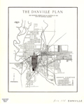 |
The Danville plan : map showing zoning plan as adopted by the city of Danville, Illinois. | Zoning--Illinois--Danville--Maps. | Scale [ca. 1:31,680]. [Danville? : City of Danville?, 193-?]. 1 map ; 29 x 24 cm. |
 |
Block data map, Detroit, Michigan, real property survey / sponsored by Detroit Housing Commission, May-September 1938. | Housing--Michigan--Detroit--Maps. Land use--Michigan--Detroit--Maps. Ethnology--Michigan--Detroit--Maps. |
Scale [ca. 1:7,000]. [Detroit? : Detroit Bureau of Governmental Research?, 1939]. 10 maps ; on sheets 148 x 105 cm. |
   |
Land use map, Detroit, Michigan, real property survey / sponsored by Detroit Housing Commission, May-September 1938. | Land use--Michigan--Detroit--Maps. | Scale [ca. 1:13,000]. [Detroit? : Detroit Bureau of Governmental Research?, 1939]. 3 maps ; on sheets 148 x 105 cm. |
   |
Land coverage map, Detroit, Michigan, real property survey / sponsored by Detroit Housing Commission, May-September 1938. | Land use--Michigan--Detroit--Maps. | Scale [ca. 1:13,000]. [Detroit? : Detroit Bureau of Governmental Research?, 1939]. 3 maps ; on sheets 148 x 105 cm. |
 |
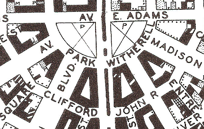
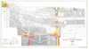
Map showing parking lots in central district : [Detroit]. | Parking facilities--Michigan--Detroit--Maps. Central business districts--Michigan--Detroit--Maps. |
Scale [ca. 1:4,800]. Detroit : City Plan Commission, 1936. 1 map ; 58 x 45 cm. |
 |
The zoning map of Flossmoor, Illinois / Jacob L. Crane, Jr., consultant, Chicago, Illinois, March 1932. | Zoning--Illinois--Flossmoor--Maps. | Scale 1:2,400. [Flossmoor? : City of Flossmoor?, 1932?]. 1 map ; 36 x 43 cm. |
 |
Zoning map of Geneva, Kane County, Illinois / prepared by Wells Engineering Co., surveyors, Geneva, Illinois. | Zoning--Illinois--Geneva--Maps. | Scale [ca. 1:4,800]. Geneva, Ill. : Wells Engineering Co., [193-?]. 1 map ; 56 x 58 cm. |
 |
Zoning plan, city of Harvey, Cook County, Illinois / Paul G. Robinson, city engineer, Harvey, Ill. | Zoning--Illinois--Harvey--Maps. | Scale 1:4,800. [Harvey, Ill. : Office of City Engineer, 1930?]. 1 map :b photocopy ; 89 x 120 cm. Blue line print. |
 |
Village of Hinsdale, Illinois, district map : showing the districts for the use-height and area regulations / Frank D. Danielson, civil engineer. | Zoning--Illinois--Hinsdale--Maps. | Scale [ca. 1:5,500]. [Hinsdale? : s.n., 193-?]. 1 map : col. ; 57 x 53 cm. |
   |
The city plan of Kalamazoo, Michigan / Jacob L. Crane, Jr., town planner ; Geo. F. Ingalls, Geo. W. Olcott, associates. | City planning--Michigan--Kalamazoo--Maps. | Scales differ. [Kalamazoo, Mich.] : City Planning Commission : City Commission, 1929. 3 maps ; on sheets 54 x 52 cm. or less. |
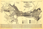 |
District map, city of Madison, Wisconsin, 1931, showing the districts for the use-height and area regulations / Harland Bartholomew, city plan engineer. | Zoning--Wisconsin--Madison--Maps. | Scale [ca. 1:13,090]. Madison : [Capital Times Co.], 1931. 1 map ; 46 x 86 cm. |
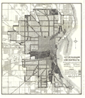 |
City of Milwaukee, preliminary plan for use districts. | City planning--Wisconsin--Milwaukee--Maps. Zoning--Wisconsin--Milwaukee--Maps. Land use--Wisconsin--Milwaukee--Maps. |
Scale [ca. 1:24,000]. [Milwaukee] : Board of Public Land Commissioners, 1920. 1 map ; 54 x 47 cm. |
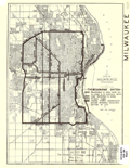 |
City of Milwaukee, Wisconsin, thoroughfare system. | Highway planning--Wisconsin--Milwaukee--Maps. | Scale [ca. 1:75,000]. [Milwaukee] : Public Land Commission, 1929. 1 map ; 27 x 19 cm. |
 |
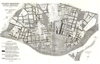
Parklawn Federal Housing Project, Milwaukee, Wisconsin / Chas. B. Bennett, city planner. | Parklawn Housing Project (Milwaukee, Wis.)--Maps. Public housing--Wisconsin--Milwaukee--Maps. Parklawn Housing Project (Milwaukee, Wis.)--Aerial views. Public housing--Wisconsin--Milwaukee--Aerial views. |
Scale [1:1,200]. Milwaukee, Wis. : Board of Public Land Commissioners, 1936. 1 map : photocopy ; 29 x 22 cm., on sheet 32 x 33 cm. Blue line print. |
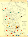 |
Zoned municipalities in Minnesota, June 1939 / map prepared by A.B. Horwitz. | Zoning--Minnesota--Maps. | Scale [ca. 1:1,225,000]. Duluth, Minn. : A.B. Horwitz?, [1939]. 1 map : hand col. ; 57 x 44 cm. |
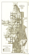 |
Map of Omaha, Nebraska, latitude 41°16', longitude 95°56', use district map / map made in 1924 by A.T.J. ; corrected Dec. 1, 1930 by A.T.J. ; use dist. map corrected Mar. 15 1931 by A.T. Jespersen including ord. no. 13938. | Land use--Nebraska--Omaha--Maps. Zoning--Nebraska--Omaha--Maps. |
Scale 1:24,000. [Omaha] : Office of City Engineer, [1931]. 1 map ; 76 x 39 cm. |
 |
Map of Omaha, Nebraska, latitude 41°16', longitude 95°56', height & area district map / map made in 1924 by A.T.J. ; height & area dist. map corrected Mar. 15 1931 by A.T. Jespersen including ord. no. 13938. | Zoning--Nebraska--Omaha--Maps. | Scale 1:24,000. [Omaha] : Office of City Engineer, [1931]. 1 map ; 76 x 39 cm. |
  |
District map, Peoria, Illinois. | Zoning--Illinois--Peoria--Maps. | Scale [ca. 1:24,090]. [Peoria? : City of Peoria?, between 1930 and 1934?]. 2 maps ; on sheets 61 x 41 cm. |
 |
St. Louis, Missouri, use district map, December 1925 / St. Louis, Missouri, Zoning Commission ; Harland Bartholomew, engineer. | Zoning--Missouri--Saint Louis--Maps. | Scale [ca. 1:16,000]. St. Louis, Mo. : Zoning Commission, [1925]. 1 map ; 75 x 121 cm. |
 |
St. Louis, Missouri, height & area district map, December 1925 / St. Louis, Missouri, Zoning Commission ; Harland Bartholomew, engineer. | Zoning--Missouri--Saint Louis--Maps. | Scale [ca. 1:16,000]. St. Louis, Mo. : Zoning Commission, [1925]. 1 map ; 76 x 122 cm. |
 |
The zone map of the city of Shaker Heights, Ohio, 1932 / F.A. Pease Engineering Company. | Zoning--Ohio--Shaker Heights--Maps. Real property--Ohio--Shaker Heights--Maps. |
Scale [ca. 1:6,000]. [Ohio?] : F.A. Pease Engineering Co., 1932. 1 map : col. ; 67 x 123 cm. |
 |
A development plan for Greenfield Park : approved 1931 / Milwaukee County Park Commission ; Milwaukee County Regional Planning Dept., Office of Landscape Architect ; plan studied by A.L.B.-E.R.G. ; drawn by E. Gruettner. | Greenfield Park (West Allis, Wis.)--Maps. | Scale [ca. 1:3,840]. [Milwaukee] : Milwaukee County Regional Planning Dept., [1931]. 1 map : col. ; 25 x 52 cm. Oriented with north to right. |

