Government Maps of Chicago in the 1920s, 1930s, and 1940s

Government Maps of Chicago in the 1920s, 1930s, and
1940s
During the 1920s, 1930s, and 1940s, there was a slow growth in the planning role of municipal governments in many large American cities, including Chicago. Cartographic materials of various sorts were one of the byproducts of this growth. This Web page provides access to some government maps of Chicago from this period that are held at the University of Chicago Library's Map Collection.
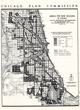
Many of these maps were compiled to assist in the implementation of particular programs. In 1922, for example, the Chicago Zoning Commission, in order to facilitate the creation of Chicago's first zoning law, compiled the first land-use map of Chicago. In the 1930s, government agencies, having acquired a mandate from the New Deal to try to alleviate urban poverty, produced maps that showed the geography of substandard housing, redlined areas, population loss, and relief distribution. As World War II began to draw to a close, the Chicago Plan Commission compiled maps in which major postwar planning efforts were proposed, and in 1946 it published the first detailed land use plan for Chicago. Many features included in on this map--certain highways and rail lines, for example--not to mention a population of 3.8 million in 1965--never quite came to pass, but the postwar city of freeways, new government-built rapid-transit lines, and large-scale urban renewal was sketched out in detail for the first time.
Other government maps from the 1920s, 1930s, and 1940s were essentially descriptive, for example, the Chicago Regional Planning Association's maps of industrial employees, subdivided land, and rail commutation time. Other "descriptive" maps focused on the work of long-existing government agencies, for example, the Sanitary Commission, the U.S. Army Corps of Engineers, the Chicago Park District, and the Cook County Forest Preserve District. Late in the 1920s, the U.S. Geological Survey, in conjunction with the Illinois Geological Survey, produced prototypes of its new 7.5 minute 1:24,000 series of topographic maps for a large part of northeastern Illinois. These maps differed from what would become the standard 7.5 minute sheets in showing individual buildings, at least in a stylized form, even in urban areas. Thus, the 1928-1929 set of USGS topographic maps of the Chicago area gives an extraordinary sense of the texture of the built environment that later editions do not.
We acknowledge that many of the maps linked on this Web page, compiled for internal agency use, are not cartographic masterpieces. Some are rather difficult to read, and we have been unable to locate a completely clear legend for the land use set. Nonetheless, these maps contain information that exists in no other form.
The maps were scanned at 400 dpi using NextImage software and saved as tiff files, which were converted to run on the Web under a program called Zoomify. You need Flash to take advantage of this software. To zoom in and out, use the scale bar to the left of the Zoomify screen or click once on the map to zoom in. To move around, hold the left mouse button down and drag either the location rectangle or the map itself. To see a larger image, click on the "Click here for full screen" button on the top left of each page. You would do well to be somewhat patient in using this software. In particular, wait until the image comes into focus before attempting a new command.
Several people contributed to the construction of this Web page. The Digital Media Laboratory let Map Collection staff use its Contex scanner, and Dale Mertes of the Digital Media Lab provided an enormous amount of assistance. Joost Dupon of the Map Collection did most of the scanning and image preparation. And Chris Havlin of the Map Collection, with the help of head of conservation Ann Lindsey, did some last-minute emergency repair work on certain sheets.
The 1920s, 1930s, and 1940s were of course also the period when social scientists first discovered Chicago on a large scale. See the companion Web pages, Social Scientists Map Chicago and Chicago in the 1920s and 1930s, for links to some of the cartographic products of this work.
There are some additional government maps of Chicago from this period at the Encyclopedia of Chicago Website.
Comments are welcome.
--CW
| Image | Title Information | Subject Headings | Description |
|---|---|---|---|
 |
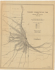
[Chicago zoning survey maps]. | Land use--Illinois--Chicago--Maps. Zoning--Illinois--Chicago--Maps. |
Scale [ca. 1:8,000]. [Chicago : Chicago Zoning Commission, 1922]. maps : photocopies ; on sheets 80 x 100 cm. Blue line prints. |
 |
[7.5 minute series (topographic) : Chicago and vicinity] / topography by O.H. Nelson ; culture and drainage in part compiled from aerial photographs taken by Air Corps, U.S. Army ; control by U.S. Geological Survey, Corps of Engineers, U.S. Army, U.S. Lake Survey, and City of Chicago, and from railroad valuation surveys. | Chicago (Ill.)--Maps, Topographic. Chicago Metropolitan Area (Ill.)--Maps, Topographic. |
Scale 1:24,000. Washington, D.C. : Geological Survey ; Urbana, Ill. : Geological Survey Division, 1928-1929. maps : col. ; on sheets 69 x 61 cm. |
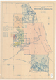 |
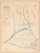
The Sanitary District of Chicago : showing annexations and municipalities / S. Reed. | Sewage disposal--Illinois--Chicago Region--Maps. Metropolitan Sanitary District of Greater Chicago--Maps. |
Scale [ca. 1:126,720]. [Chicago : Metropolitan Sanitary District], 1927. 1 map : col. ; 55 x 39 cm. |
 |
Industrial employees in the region of Chicago, 1928. | Labor supply--Illinois--Chicago Region--Maps. Industries--Chicago Region--Maps. |
Scale [ca. 1:240,000]. [Chicago] : Chicago Regional Planning Association, 1928. 1 map ; 87 x 73 cm. |
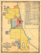 |
Map of Chicago showing growth of the city by annexations. | Chicago (Ill.)--History--Maps. Annexation (Municipal government)--Illinois--Chicago--Maps. |
Scale [ca. 1:84,500]. [Chicago] : Dept. of Public Works, Bureau of Maps and Plats, [1930?]. 1 map : col. ; 60 x 46 cm. |
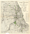 |
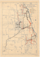
Map of Cook County, Illinois, 1930 : showing highways and forest preserves. | Cook County (Ill.)--Maps. Forest reserves--Illinois--Cook County--Maps. Roads--Illinois--Cook County--Maps. |
Scale [ca. 1:126,720]. [Chicago] : Board of County Commissioners, [1930]. 1 map : col. ; 73 x 65 cm. |
 |
Subdivided and occupied land in the vicinity of Chicago. | Land use--Illinois--Chicago--Maps. Land use--Illinois--Chicago Metropolitan Area--Maps. |
Scale [ca. 1:125,000]. [Chicago] : Chicago Regional Planning Association, [193-]. 1 map ; 84 x 72 cm. |
 |
Map of the Sanitary District of Chicago showing dilution system and sewage treatment projects. | Sewage disposal--Illinois--Chicago Region--Maps. Metropolitan Sanitary District of Greater Chicago--Maps. |
Scale [ca. 1:125,000]. [Chicago : Metropolitan Sanitary District?], 1931. 1 map : col. ; 67 x 47 cm. |
 |
Proportion of population receiving relief in Chicago by sub-communities, October, 1933. | Public Welfare--Illinois--Chicago--Maps. | Scale [ca. 1:125,000]. [Chicago] : Cook County Statistical Service : Illinois Emergency Relief Commission, [1933]. 1 map ; 43 x 24 cm. |
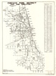 |
Chicago Park District map and directory : showing all parks and boulevards in the District / drawn by L.Z. Plebanak. | Parks--Illinois--Chicago--Maps. | Scale [ca. 1:100,000]. [Chicago] : Recreational Division, Publicity and Promotion, 1934. 1 map ; 53 x 39 cm. |
 |
Map of Chicago waterways. | Waterways--Illinois--Maps. | Scale [ca. 1:95,000]. [Chicago, Ill. : United States Army, Corps of Engineers Office?, 1934?]. 1 map : photocopy ; 59 x 45 cm. Blue line print |
 |
Railway commutation time in the region of Chicago, March 1934. | Railroads--Illinois--Chicago--Maps. Railroads--Illinois--Chicago Metropolitan Area--Maps. Railroads--Illinois--Chicago Metropolitan Area--Passenger traffic--Maps. |
Scale [ca. 1:250,000]. [Chicago] : Chicago Regional Planning Association, [1934]. 1 map ; 83 x 66 cm. |
 |
Per cent increase and decrease of population from 1910 to 1934. | Chicago (Ill.)--Population--Maps. | Scale [ca. 1:62,500]. Chicago : Chicago Housing Authority, [1938]. 1 map : hand col. ; 83 x 56 cm. |
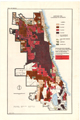 |
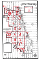
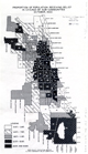
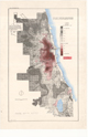
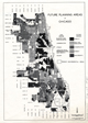
Mortgage risk classified by districts : [Chicago, Illinois]. | Housing--Illinois--Chicago--Maps. Mortgage loans--Illinois--Chicago--Maps. Real property--Illinois--Chicago--Maps. |
Scale [ca. 1:64,000]. Chicago : Chicago Housing Authority, [1938]. 1 map : hand col. ; 73 x 45 cm. |
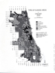 |
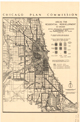
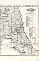
Types of planning areas in Chicago, 1942 / prepared by Chicago Plan Commission. | City planning--Illinois--Chicago--Maps. | Scale [ca. 1:190,000]. [Chicago] : Chicago Plan Commission, 1943. 1 map ; 28 x 22 cm. |
 |
Future planning areas of Chicago. | City planning--Illinois--Chicago--Maps. | Scale [ca. 1:190,000]. [Chicago] : Chicago Plan Commission, 1943. 1 map ; 28 x 22 cm. |
 |
Areas for residential redevelopment in Chicago within designated neighborhoods in accordance with the Comprehensive City Plan. | Urban renewal--Illinois--Chicago--Maps. Land use--Illinois--Chicago--Maps. |
Scale [ca. 1:132,000]. [Chicago] : Chicago Plan Commission, 1945. 1 map ; 43 x 28 cm. |
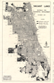 |
Vacant land suitable for residential development, December 1945. | Land use--Illinois--Chicago--Maps. Vacant lands--Illinois--Chicago--Maps. City planning--Illinois--Chicago--Maps. |
Scale [ca. 1:117,000]. Chicago : Chicago Plan Commission, 1945. 1 map ; 43 x 28 cm. |
 |
Areas for new housing in Chicago : within designated neighborhoods in accordance with the comprehensive city plan. | Housing--Illinois--Chicago--Maps. | Scale [ca. 1:135,000]. [Chicago] : Chicago Plan Commission, 1945. 1 map ; 43 x 28 cm. |
 |
Major housing developments in Chicago, 1935-1946. | Housing--Illinois--Chicago--Maps. | Scale [ca. 1:125,000]. [Chicago] : Chicago Plan Commission, 1946. 1 map ; 43 x 28 cm. |
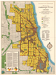 |
Preliminary comprehensive city plan of Chicago : a generalized presentation of the physical elements of the city plan designed for a population of 3,800,000 by 1965. | City planning--Illinois--Chicago--Maps. | Scale [ca. 1:36,000]. Chicago : Chicago Plan Commission, 1946. 1 map : col. ; 124 x 92 cm. |

