European Transportation Maps of the 19th Century
European Transportation Maps of the 19th Century
This Web page provides access to some of the maps showing European transportation facilities during the 19th century that are held at the University of Chicago Library's Map Collection.
The maps document an extraordinary change. At the beginning of the 19th century movement was largely along dirt roads and depended on horses or walking. Canals, some associated with the nascent Industrial Revolution, existed in a few places, but movement along the canals was also dependent on animal power. It could take weeks to cross Europe. By the end of the 19th century, transportation had become enormously faster, more reliable, and more comfortable. Steam railroad lines had penetrated everywhere except parts of Eastern Europe, northern Scandinavia, and the High Alps. Roads, even though they were starting to be paved, were secondary except at the very local level. Waterways continued to be important for bulk freight.
The maps shown are a tiny subset of all the European transportation maps produced in the 19th century. They were chosen to be representative rather then comprehensive. Numerous additional titles at the University of Chicago Library--and in other North American libraries--can be found by searching with Library of Congress subject headings. Examples include "Railroads--[Place name]--Maps, " "Roads--[Place name]--Maps, " "Inland navigation--[Place name]--Maps, " "Shipping--[Place name]--Maps, " and "Transportation--[Place name]--Maps." General maps also often show transportation facilities; it is hard to imagine a map of almost anywhere in Europe published between, say, the 1840s and World War I that did not show railroad lines.
The maps were scanned at 400 dpi using NextImage software and were saved as tiff files
You can access these files in three different ways:
[1] Click on the thumbnails below to see the files in a program called Zoomify. Zoomify breaks the original tiff files into tiny jpegs, so you can zoom in and out and move around quickly and efficiently. Zoomify requires Flash and so won't work on many mobile phones.
[2] You can also see the files through Luna. Luna, like Zoomify, allows you to zoom in and out and to move around. It also allows download of jpeg versions of the files (click "Export"). To access the Luna files, click on the "Click here for Luna version" button.
[3] Alternatively, use the spatial index below. It will take you to a page from which you have a choice between access via Zoomify and access via Luna.
The original tiff files are also available. E-mail from the "Questions about this page?" button below.
Downloaded files are freely available for personal or scholarly use. If you use the images in a publication, we expect that you will mention that the original maps--and the files--are from the University of Chicago Library's Map Collection.
Several people contributed to the construction of this Web site. Joel Thomas of the Map Collection did nearly all the scanning, image preparation, and cataloging, and did some conservation work as well. Renee Martonik of the Cataloging Department provided advice on the latest rules for cataloging Internet resources. Kathleen Degnan of the Digital Library Development Center did the necessary server preparation. Bridget Madden of the University of Chicago's Visual Resources Center and Charles Blair of the Library's Digital Library Development Center developed a protocol in 2015 that allows access via Luna. Bobby Butler of the Map Collection improved a few files before this conversion and then edited the html on the Map Collection pages to point to the Luna versions. The spatial index was created by map assistant Sam Brown in September 2015.
The maps are listed by date.
Comments are welcome.
--CW
| Image | Title Information | Subject Headings | Description |
|---|---|---|---|
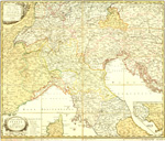 |
Post-Karte von Ober und Mittel Italien : nebst den angränzenden Theilen von Frankreich und Deutschland bis Wien / nach den grossen Karten von Dalbe, und Cassini, entworfen von M. Raginger u. gestochen von F. Müller. | Postal service--Italy--Maps. Italy--Maps. |
Scale [ca. 1:1,170,000]. Wien : Bey Artaria, 1803. 1 map : hand col. ; 52 x 62 cm., on sheet 55 x 64 cm. |
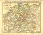 |
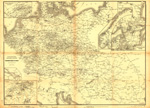
Postkarte durch ganz Deutschland und einige angränzende Länder = Postarum seu veredariorum stationes per Germanium et provincias adiacentes. | Postal service--Germany--Maps. Postal service--Europe, Central--Maps. Roads--Germany--Maps. Roads--Europe, Central--Maps. |
Scale [ca. 1:2,670,000]. Nürnberg : Bey Homanns Erben, 1805. 1 map : col. ; 44 x 55 cm., on sheet 52 x 65 cm. |
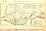 |
Canal royal des Pyrénées. | Canals--France, Southwest--Maps. Canal du Midi (France)--Maps. |
Scale [ca. 1:1,000,000]. [France : s.n., ca. 1820?]. 1 map : hand col. ; 31 x 59 cm., on sheet 41 x 61 cm. |
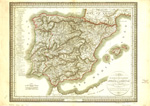 |
Carte des routes de postes et itinéraires d'Espagne et de Portugal / par Ch. Picquet, dressée par Lapie, ingr. géographe. | Postal service--Spain--Maps. Postal service--Portugal--Maps. Roads--Spain--Maps. Roads--Portugal--Maps. |
Scale [ca. 1:2,495,000]. Vienne : Artaria et Compag., 1823. 1 map : hand col. ; 43 x 56 cm., on sheet 52 x 74 cm. |
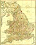 |
Cary's six sheet map of England and Wales, with part of Scotland : on which are carefully laid down all the direct and principal cross roads, the course of the rivers, and navigable canals, cities, market and borough towns, the principal villages, parks, &c., compiled from the most recent surveys. | England--Maps. Wales--Maps. Transportation -- Great Britain -- Maps. |
Scale [ca. 1:510,000]. London : J. Cary, 1826. 1 map : col. ; 131 x 100 cm. |
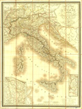 |
Carte routière de l'Italie indiquant les divisions politiques de ses divers états / par A.H. Brué, géographe. | Roads--Italy--Maps. | Scale [ca. 1:2,000,000]. Paris : Chez Chles. Simonneau, 1838. 1 map : col. ; 80 x 59 cm., on sheet 87 x 66 cm. |
 |
Osborne's map of the London & Birmingham Railway | London and Birmingham Railway--Maps. Railroads--England--Maps. |
Scale [ca. 1:300,000]. Birmingham : E.C. & W. Osborne, 1838. 1 map ; 35 x 65 cm. |
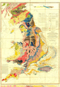 |
A geological map of England, Wales, and part of Scotland : showing also the inland navigation by means of rivers & canals, with their elevation in feet above the sea, together with the rail roads & principal roads / by J. & C. Walker. | Geology--England--Maps. Geology--Wales--Maps. Transportation--England--Maps. Transportation--Wales--Maps. |
Scale [ca. 1:570,000]. London : J. & C. Walker, 1838. 1 map : col. ; 135 x 95 cm. |
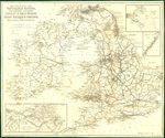 |
Map exhibiting the navigable rivers, the completed & proposed canals & rail-roads of Great Britain & Ireland, with the coal fields, light houses &c. / engraved by S. Hall. | Transportation--Great Britain--Maps. Railroads--British Isles--Maps. Canals--British Isles--Maps. |
Scale [ca. 1:1,400,000]. London : Longman & Co., [184-?]. 1 map ; 51 x 62 cm., on sheet 55 x 65 cm. |
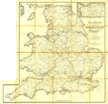 |
Cheffins's map of the English & Scotch railways. | Railroads--Great Britain--Maps. | Scale [ca. 1:840,000]. London : Charles F. Cheffins, [1844]. 1 map : col. ; 67 x 69 cm. |
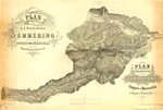 |
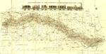
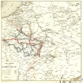
Plan der k.k. Staatsbahn über den Semmering zwischen Gloggnitz und Mürzzuschlag im Kaiserthume Oesterreich = Plan du Chemin de fer de l'état franchissant le Semmering entre Gloggnitz et Murzzüschlag, empire d'Autriche / aufgenommen u. gezeichnet v. J. Kitzler, K.K. Jngen, asst., 1853. | Semmeringbahn--Maps. Railroads--Austria--Semmering (Region)--Maps. |
Scale [ca. 1:30,000]. Wien: Zinkstich und Druck von Wenigk, [1853] 1 map ; on sheet 52 x 77 cm. |
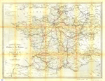 |
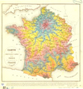
Nouvelle carte des chemins de fer français et voies navigables / dessinée et gravée par J. Sédille. | Railroads--France--Maps. Waterways--France--Maps. |
Scale 1:2,000,000. Paris : Viallet & cie. : en vente chez Arnauld de Vresse, éditeur, 1861. 1 map : col. ; 49 x 65 cm. |
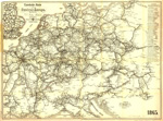 |
Eisenbahn-Karte von Central Europa / bearbeitet von Julius Michaelis ; lith. v. J.H. Klahr in Dresden. | Railroads--Europe, Central--Maps. | Scale [ca. 1:2,000,000]. Dresden : Königl. Hof-Buchhandlung von Hermann Burdach, 1865. 1 map ; 66 x 89 cm. |
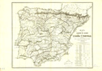 |
Mapa de los caminos de hierro de España y Portugal. | Railroads--Spain--Maps. Railroads--Portugal--Maps. |
Scale [ca. 1:1,330,000]. Madrid : Gaçeta de los Caminos de Hierro, 1868. 1 map ; 73 x 89 cm. |
 |
Carte générale du réseau des chemins de fer de l'est / gravé chez Avril fres. et Wuhrer. | Railroads--France--Maps. Canals--France--Maps. Railroads--Europe, Western--Maps. Canals--Europe, Western--Maps. |
Scale 1:1,000,000. Paris : A. Logerot, 1872. 1 map : col. ; 66 x 85 cm. |
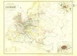 |
Nouvelle carte des voies de communication de l'Europe : par les chemins de fer et la navigation maritime / dressée par A. Vuillemin ; gravé par G. Lorsignol ; la lettre par Varinot. | Transportation--Europe--Maps. Railroads--Europe--Maps. |
Scale 1:6,530,000. [Paris : s.n. 187-?]. 1 map : col. ; 42 x 42 cm. |
  |
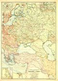
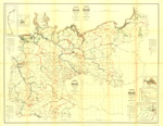
Verkehrs-Karte von Oesterreich-Ungarn : nebst den angrenzenden Ländern des deutschen Reiches, von Russland und der Europäischen Türkei / bearbeitet von W. Liebenow. | Transportation--Austria--Maps. Transportation--Hungary--Maps. Transportation--Europe, Eastern--Maps. Transportation--Balkan Peninsula--Maps. Austria--Maps. Hungary--Maps. Europe, Eastern--Maps. Balkan Peninsula--Maps. |
Scale 1:1,250,000. Berlin : Berliner Lithogr. Jnstituts, [between 1873 and 1878]. 1 map : col. ; 128 x 133 cm., on sheet 138 x 142 cm. |
  |
Carte spéciale des voies navigables qui mettent en communication Paris, le nord de la France, et la Belgique : indiquant la navigation naturelle, artificielle, et maritime, le flottage en trains, l'emplacement de toutes les écluses, celui des bureaux établis pour la perception des droits de navigation, le tracé des chemins de fer, avec un tableaux synoptique comprenant les principaux renseignements qui peuvent interesser le commerce et le guider dans la direction des transports / par Ernest Grangez ; revue et complétée par E. Blondin. | Inland navigation--France--Maps. Waterways--France--Maps. Inland navigation--Belgium --Maps. Waterways--Belgium--Maps. |
Scale 1:300,000. Paris : Institut géographique de Paris : Ch. Delagrave, 1875. 1 map on 2 sheets ; 114 x 90 cm., sheets 66 x 100 cm. |
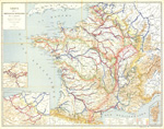 |
Carte de la navigation intérieure de la France : présentant le classement du réseau navigable en lignes principales et secondaires / Regnier, graveur et imprimeur. | Inland navigation--France--Maps. Rivers--France--Maps. Canals--France--Maps. |
Scale 1:1,250,000. Paris : Regnier, 1878. 1 map : col. ; 78 x 101 cm. |
 |
Carte des communications rapides entre Paris et le reste de la France / dressée par E. Martin ; E. Chevaillier, del. | Railroads--France--Passenger traffic--Maps. | Scale [ca. 1:2,700,000]. [Paris : s.n.], 1882. 1 map : col. ; 43 x 43 cm. |
 |
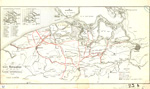
Eisenbahn- und Schiffahrts-Karte der Kaiserreiche von Russland und der Türkei / von E.G. Ravenstein ; Stich und Druck der Geogr. Anstalt von L. Ravenstein, Frankfurt a. M. | Railroads--Russia--Maps. Railroads--Turkey--Maps. Shipping--Russia--Maps. Shipping--Turkey--Maps. |
Scale 1:5,000,000. Frankfurt a/Main : Jaeger'sche Buch- Papier- u. Landkartenhandlung, [1883?]. 1 map : col. ; 84 x 61 cm. |
 |
Carte hydrographique de la Flandre septentrionale. | Inland navigation--Belgium--Maps. Hydrography--Belgium--Maps. |
Scale 1:160,000. Antwerp : Établ. géogr. de Alois Scheepers, [189-?]. 1 map : col. ; 39 x 75 cm. |
 |
Karte der flössbaren und der schiffbaren Wasserstrassen des Deutschen Reiches im Massstab von 1:100 / entworfen und gezeichnet von Victor Kurs. | Waterways--Germany--Maps. Inland navigation--Germany--Maps. |
Scale 1:1,000,000. Berlin : Lithografisches Institut von Wilhelm Greve, 1894. 1 map : col. ; 98 x 127 cm. |
 |
Übersichts-Karte zu dem Verzeichnisse der Fahrscheine. | Railroads--Germany--Maps. Railroads--Europe, Central--Maps. |
Scale [ca. 1:1,800,000]. [Berlin] : Verein Deutscher Eisenbahn-Verwaltunge, 1897. 1 map ; 72 x 98 cm. |

