Late 19th- and Early 20th-Century Latin American Cities
Late 19th- and Early 20th-Century Latin American Cities
Click on the links below to access scans of some of the late 19th- and early 20th-century sheet maps of Latin American cities that are held at the University of Chicago Library's Map Collection.
The cities portrayed on these maps were not at all alike.
Some of the smaller and more out-of-the-way places--Oaxaca and Puno, for example--still had the morphology of late colonial cities. In Spanish-speaking Latin America, this meant that city streets were built on a simple grid centered on a plaza surrounded by governmental and religious buildings. The non-Spanish-speaking cities were similar but less uniform in their street pattern. (Cuzco and to a much smaller extent Mexico City were the only substantial cities whose form was influenced by pre-colonial Amerindian settlements.)
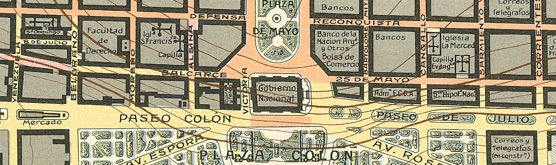
A few larger cities, however--Buenos Aires and Rio de Janeiro, for example--may have retained a colonial street pattern in their core but were in the process of being transformed completely. Thanks to growing commerce and industry, and massive immigration from abroad or from the countryside, such cities were expanding quickly. Buenos Aires in around 1910 became the first Latin American city to reach a population of 1,000,000. Rio followed a few years later. Suburban railways and trams and, in Buenos Aires in 1913, a subway line allowed the rapid spreading out of the city. European planning ideas encouraged the establishment of large parks. Housing of rich people and poor people became quite separated. Cities like Buenos Aires and Rio de Janeiro in the early years of the 20th century were in the process of becoming part of the modern world.
The maps were scanned at 400 dpi and saved as tiff files.
You can access these files in two different ways:
[1] Click on the thumbnails below to see the files in a program called Zoomify. Zoomify breaks the original tiff files into tiny jpegs, so you can zoom in and out and move around quickly and efficiently. Zoomify requires Flash and so won't work on many mobile phones.
[2] You can also see the files through Luna. Luna, like Zoomify, allows you to zoom in and out and to move around. It also allows download of jpeg versions of the files (click "Export"). To access the Luna files, click on the "Click here for Luna version" button.
The original tiff files are also available. E-mail from the "Questions about this page?" button below.
Downloaded files are freely available for personal or scholarly use. If you use the images in a publication, we expect that you will mention that the original maps--and the files--are from the University of Chicago Library's Map Collection.
Several people contributed to the construction of this Web site. Joost Dupon of the Map Collection did most of the scanning and most of the Photoshop manipulation as well. The Digital Media Laboratory let Map Collection staff use its Contex scanner; Dale Mertes of the Digital Media Laboratory was particularly helpful. John Jung and other staff members of the Digital Library Development Center helped with the programming. Bridget Madden of the University of Chicago's Visual Resources Center and Charles Blair of the Library's Digital Library Development Center developed a protocol in 2015 that allows access via Luna. And Bobby Butler, Emily Thompson, and Michael Weinrib of the Map Collection edited this page to point to the Luna versions.
The links below are in alphabetical order by city name.
Comments are welcome. Please use the "Questions and comments about this page" form below.
--CW
| Image | Title Information | Subject Headings | Description |
|---|---|---|---|
 |
Plano de Arequipa / levantado por Alberto de Rivero. | Arequipa (Peru)--Maps. | Scale 1:5,000. Lima, Perú : T. Scheuch, 1917. 1 map : col. ; on sheet 112 x 87 cm. |
 |
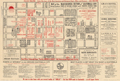
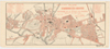
Municipio de Buenos-Aires y parte del partido de Avellaneda / publicado por Pablo Ludwig, cartógrafo, según los datos mas recientes. | Buenos Aires (Argentina)--Maps. | Scale 1:35,000. Buenos Aires : Pablo Ludwig, 1912. 1 map : col. ; 60 x 61 cm. |
 |
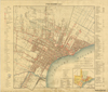
Plano de la ciudad de Buenos Aires, capital de la República Argentina con el trazado general de calles / Alfredo Berisso, Jefe de la Sala de Dibujo ; Manrique Ruiz, Adolfo Kliman, dibujantes. | Buenos Aires (Argentina)--Maps. | Scale 1:10,000. Buenos Aires : Municipalidad de la Capital, 1916. 1 map on 7 sheets: col. ; sheets 74 x 111 cm. Oriented with north to right. |
 |
Plano del Callao / por Santiago M. Basurco, ingeniero de estado. | Callao (Callao, Peru)--Maps. | Scale 1:10,000. Lima : Lit. San Cristoval, 1900. 1 map : col. ; 31 x 48 cm., on sheet 45 x 68 cm. Oriented with north to lower left. |
 |
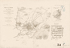
Le Cuzco (CCozcco) : première capitale de l'empire Tahuantin-Suyu (Haut et Bas Pérou) / dressé et dessiné par Charles Wiener, 1876-1877. | Cuzco (Peru)--Maps. | Scale 1:5,000. [Paris] : Société de géographie, [1878]. 1 map : col. ; 27 x 38 cm. |
 |
Plano del Cuzco : estudio de la conducción del agua / por los ingenieros Enrique E. Silgado y Mauro Valderrama. | Cuzco (Peru)--Maps. Water-supply--Peru--Cuzco--Maps. |
Scale 1:5,000. Lima : Lit. y Tip. Nacional M. Badiolay Cia., 1900. 1 map : col. ; 76 x 50 cm. Oriented with north to top right. |
  |
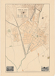
Map of the main business section of Guatemala City : showing location of points of historic interest and of principal business firms. | Guatemala (Guatemala)--Maps. Central business districts--Guatemala--Guatemala--Maps. |
Scale not given. Guatemala, C.A. : F.A. Sherwood, [192-?]. 1 map : col. ; 25 x 40 cm. on sheet 35 x 52 cm. Map of Guatemala City on verso. |
 |
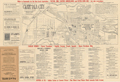
Military map of Habana and vicinity, 1898 / drawn by C.H. Ourand. | Havana (Cuba)--Maps. Havana Region (Cuba)--Maps. |
Scale [ca. 1:18,000]. Washington, D.C. : Adjutant General's Office, Military Information Divison, [1898]. 1 map : col. ; 63 x 87 cm. |
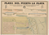 |
Plano del puerto La Plata : proyectado por el ingeniero J.A.A. Waldorp, director técnico de las obras, Empresa Constructora Sres. La Valle, Medici & Cia. / compuesto según los datos oficiales de la Dirección Técnica por el Ingeniero D. Ernesto Lans, ayudante de la Dirección Técnica, y Don Luis Felipe Scuvero Ondario, dibujante de la Empresa Constructora. | La Plata (Argentina)--Maps. Harbors--Argentina--La Plata--Maps. |
Scale not given. Ensenada : La Valle, Medici & Cia., 1886. 1 map : col. ; 33 x 78 cm., on sheet 88 x 126 cm. (See note.) |
 |
Plano de Lima, trabajos de canalización y saneamento : executados siendo alcalde Don Federico Elguera, inspector de aguas P. y C. Don Eduardo Lavergne / por Julio E. Ribeyro, ingo. | Water-supply--Peru--Lima--Maps. Lima (Peru)--Maps. |
Scale 1:10,000. [Lima] : H.C.P., 1904.. 1 map : col. ; 54 x 55 cm. |
 |
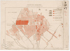
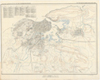
Carta de la República Mexicana a la 100 000a. Hoja 19-I-M. | Mexico City Region (Mexico)--Maps, Topographic. Mexico City (Mexico)--Maps, Topographic. |
Scale 1:100,000. [Mexico City] : Secretaría de Estado y del Despacho de Fomento, Comisión Geográfica de Guerra y Fomento, 1909. 1 map : col. ; 43 x 56 cm. |
 |
Plan d'Oajaca / Capitaine Niox fecit ; H. Girard sculpt. | Oaxaca de Juárez (Mexico)--Maps. Oaxaca de Juárez Region (Mexico)--Maps. |
Scale 1:40,000. [Paris] : J. Dumaine, [1874] ([Paris] : Impe. Dufrénoy). 1 map ; on sheet 58 x 37 cm. "G. Niox. Expédition du Mexique, 1861-1867. Planche 4." |
 |
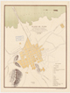
Paramaribo, 1916-17. | Paramaribo (Suriname)--Maps. | Scale 1:10,000. 'S Gravenhage : Topographische Inrichting, 1920. 1 map : col. ; 58 x 56 cm., on sheet 63 x 74 cm. |
 |
Plan de Puebla et des environs, pour servir à l'intelligence du combat du 5 mai 1862, livré par le Général Lorencez sur les hauteurs de Guadeloupe, et des opérations du siège dirigé par le Gal. Forey (du 16 mars au 18 mai 1863) / Capitaine Niox fecit. | Puebla de Zaragoza (Mexico)--Maps. Puebla de Zaragoza Region (Mexico)--Maps. |
Scale 1:40,000. [Paris] : J. Dumaine, [1874]. 1 map ; on sheet 40 x 58 cm. "G. Niox. Expédition du Mexique, 1861-1867. Planche 3." |
 |
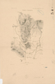
Plano de Puno / leventado por Teobaldo Eléspuru por órden de la Direccióln de Obras Públicas. | Puno (Puno, Peru)--Maps. | Scale 1:4,000. Lima : Lit. Nacional M. Badiola y Co., 1901. 1 map : col. ; 61 x 47 cm. Oriented with north to left. |
 |
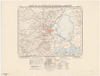
Plano de la ciudad de Quito en el centenario de la Batalla de Pichincha, mayo 24 de 1922. | Quito (Ecuador)--Maps. | Scale 1:15,000. [Ecuador : s.n., 1922]. 1 map : col. ; 21 x 46 cm. Oriented with north to top right. |
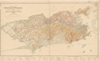 |
Carta do Districto Federal / levantada, desenhada e impressa pelo Serviço Geographico Militar. | Rio de Janeiro (Brazil)--Maps. Rio de Janeiro Region (Brazil)--Maps. Rio de Janeiro (Brazil : State)--Maps. |
Scale 1:50,000. [Brazil] : Serviço Geographico Militar, 1922. 1 map : col. ; 76 x 143 cm. |

