Library digitizes maps for study of kelp in a changing climate
“Kelp are habitat for hundreds—probably thousands of species: fishes, invertebrates, etcetera,” explained Cathy Pfister, Professor in University of Chicago’s Department of Ecology and Evolution. “They are a natural habitat, just like a coral reef, that is the only place where some animals survive.”
Concerns have been raised about downward trends in kelp’s abundance worldwide. Seeking more information about long-term changes in kelp abundance, Pfister discovered that the University of Chicago Library holds rare World War I-era maps showing the location of kelp forests in the Pacific Northwest. At her request, the Library’s Preservation staff digitized these maps, and Pfister and her collaborators compared the early 20th-century survey findings to aerial censuses of two canopy kelp species in Washington State waters from 1989 to 2015.
Surveying kelp beds in anticipation of World War I
The maps in the UChicago Library’s collection were made in anticipation of international conflict rather than global warming. In the early 1900s, the U.S. Department of Agriculture recognized a problem. The United States relied heavily on fertilizer to grow crops and support its burgeoning economy, yet a crucial ingredient for fertilizer — potash, a mixture of potassium and salts — was mined almost exclusively in Germany. German mines supplied nearly the entire world’s supply of potash, and at the time the U.S. used about a fifth of its output.
Seeking ways to ease this dependency—and possibly aware that potash is also an ingredient in gunpowder—the USDA commissioned several surveys of an alternative source of potash: kelp beds in the Pacific Northwest. The large, hardy seaweeds are a natural source of potassium, nitrogen, and salts, and kelp worldwide have been used historically as fertilizer. If kelp could be harvested and processed in large enough quantities, it could be a viable source of potash to offset German imports.
So, the USDA sent surveyors — including George Rigg, an ecologist from the University of Washington — to map the kelp beds along the coast of California, Oregon, Washington and Alaska. Rigg set out in a yacht with a 40-horsepower motor and mapped the Washington coastline in 1911-12.
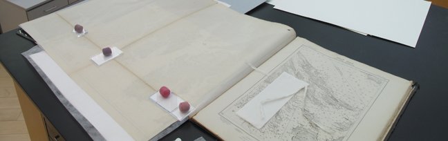
One hundred and five years later, Pfister was made aware of the maps and was surprised to see a folio listed in the University of Chicago Library Catalog. With a few keystrokes, she had them retrieved by the robotic cranes in the Joe and Rika Mansueto Library’s automated storage and retrieval system. Delivered into her hands were large format maps bound inside 27 x 21-inch covers. Recognizing the value and fragility of the material, and wanting to use and archive digital copies of the maps for her analysis, Pfister contacted Preservation Librarian Sherry Byrne for help.
Conserving and digitizing the maps
The Library’s Preservation team was happy to digitize the extensive collection of maps from Alaska to California and had the expertise to do so without causing damage to the brittle, 100-year-old paper they were printed on. Especially large maps that had been folded to fit inside the book’s covers were starting to tear at the folds, so Library staff reinforced those sections of paper with Japanese tissue and wheat starch paste to keep the sections of the page from separating during handling. They then built a set-up to support the large volume while opening the folded maps for digitization. Photographer Michael Kenny and Head of Digitization Kathleen Arthur captured high-resolution images and posted PDFs that are now freely available to researchers worldwide through the Library Catalog.
“Library staff members with expertise in conservation and digitization are here to enable research that requires the digitization of print and other non-digital materials,” said Byrne. “We encourage faculty, students, and other researchers to contact us to discuss the possibility of digitizing materials in our collection.”

Research findings
With digitized copies of the Library’s 1911-12 maps in hand and aerial censuses from the last 26 years, Pfister and colleagues at the Washington Department of Natural Resources were able to determine the persistence of kelp cover over the past century and compared kelp dynamics with likely environmental drivers such as local environmental variables and ocean indices for the region.
What they found is a relatively rare positive story when it comes to ecological studies in a time of accelerating climate change. The abundance of most modern kelp beds along the Washington coast has remained constant over the last century despite a seawater temperature increase of 0.72 degrees Celsius. The few exceptions are kelp beds closest to Puget Sound, Seattle and Tacoma.
“Kelp are a robust and resilient structure. You can see that in the data, as long as they have access to good water quality and waves flush through them, then they persist,” Pfister said.
Pfister and her team also studied the competition among kelp species in the area. While the kelp beds were persistent over the decades, their populations could fluctuate greatly from year to year. There are two dominant species — the annual bull kelp and the perennial giant kelp — and they fluctuated similarly, meaning that if one was abundant in a given year, so was the other. And good years, it turns out, are associated with colder seawater temperatures, an unfortunate preference for kelp as ocean temperatures continue to rise.
The study by Pfister, Helen D. Berry, and Thomas Mumford, “The dynamics of Kelp Forests in the Northeast Pacific Ocean and the relationship with environmental drivers,” was published Dec. 18, 2017, in the Journal of Ecology.
The Library and research on climate change and ecological history
“As ecologists, we’re realizing that libraries and museums have incredible archival information about how our ecosystems used to look before we really were recording it very well,” said Pfister. “So instances like this where there was an expedition that really quantified how much kelp was there are incredibly important in helping us to understand where we’ve been in these ecosystems and potentially where we’re going as the climate changes.”
The Library has a wide variety of materials that may be useful to scientists exploring ecological history, including reports, maps, and data on ecological communities and environments that have changed or disappeared due to urbanization, climate change, and other forces. One particularly well-known collection of 4500 American Environmental Photographs was created between 1891 and 1936 by UChicago faculty members and students and is fully digitized and available online. The Library’s extraordinary Map Collection is well described and discoverable in the Library Catalog, and additional maps can be found in books and other materials. For research assistance in this area, contact us at Ask a Science Librarian.

