Browse by
| Collections | |||
|---|---|---|---|
| Collection Thumbnail | Title | Formats | Subjects |
|
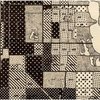
Chicago in the 1920s and 1930s: the view from the Chicago School (the Social Science Research Committee maps) "During the 1920s and 1930s numerous scholars at the University of Chicago did research on Chicago itself. These scholars, whose work is sometimes associated with the label "Chicago School," or "Chicago School of Sociology," played a major role in establishing urban studies as an important academic enterprise. All of these maps were produced under the aegis of the Social Science Research Committee or its immediate predecessor, the Local Community Research Committee. |
Formats Digital Maps |
Subjects Sociology American History Chicago and Illinois Maps |
|
Ethnographic Maps of the 19th Century 19th-century ethnographic maps that are held at the University of Chicago Library's Map Collection. Most of these maps show the distribution of particular ethnic groups or languages. A few show the geography of other aspects of culture. |
Formats Digital Maps |
Subjects Sociology Anthropology Maps |
|
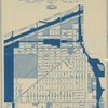
Social Scientists Map Chicago Geographer Chauncy Harris often argued that Chicago in the first half of the 20th century was the most studied city in the world. This claim is unprovable, but there were certainly an enormous number of scholarly studies of Chicago between the 1920s and the middle of the 20th century. Many of these included maps. |
Formats Digital Maps |
Subjects Sociology Political Science American History Chicago and Illinois Maps |