Advancing GIS librarianship with a national leadership grant
GIS (geographic information systems) librarians support a growing range of researchers across disciplines who use geospatial information science, including digital mapping and spatial analysis. For example, Robert Vargas, Associate Professor of Sociology and Deputy Dean of the Social Sciences, approached the University of Chicago Library to develop training for his research team on making historical maps machine readable. This training allowed Vargas and his team to investigate the social outcomes of changing ward and congressional boundaries in U.S. cities over time. In the humanities, the Library is training undergraduate research assistants to create tabular data from literary works for interactive web maps. The Contemporary Migrations project, led by Professor Josephine McDonagh of English Language and Literature and PhD student Bellamy Mitchell, visually explored migration stories found in works of poetry.
The University of Chicago Library was awarded a $133,992 National Leadership Grant from the Institute of Museum and Library Services (IMLS) to advance GIS librarianship. This grant was used to host national forums that are helping librarians to address increasingly diverse research questions as part of an initiative known as "GIS Librarians for Open Workflows" (GLOW). In collaboration with the University Consortium for Geographic Information Science (UCGIS), the project also aims to reshape the landscape of geospatial information services and open educational resources (OERs)--materials that are freely available for the public to use, share, and build upon their content. In addition to open textbooks, OERs include tutorials, guides, and other instructional material. Leading the effort are Cecilia Smith, Director of Digital Scholarship at the UChicago Library and a former GIS and Maps Librarian, and Diana Sinton, Senior Research Fellow at UCGIS.
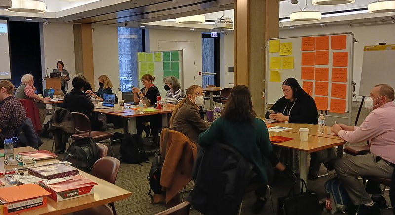
Three successful forums took place with librarians across North America. At Forum 1 at the UChicago Library in December 2022, participants engaged in discussions and interactive activities to address challenges related to consultative workflows and the integration of OERs into research support services. Grounding the conversations was a focus on three common geospatial research topics: public health, infrastructure, and social justice. For example, public health researchers use GIS to study topics such as the spread of disease, access to health and nutrition resources, environmental factors of health, addiction and more. Understanding rates and propositions, visualization methods, and working with sensitive data are important concepts GIS librarians must be knowledgeable about to support these researchers in their work. Forum participants identified characteristic features of research needs related to each these areas and useful resources for support providers.
At Forum 2, held in May 2023 also at UChicago Library, GIS librarians explored the connection between their existing workflows and geospatial OERs. And at a final virtual forum, attendees built on the preceding events by brainstorming solutions to common challenges. Insights included ways to provide clear and consistent service expectations, creating modular training materials for reuse in different contexts, effective consultative workflows with example scripts for librarians, and a geospatial framework for assessing OERs as suitable for instruction and consultations.
This work directly supports the UChicago community as we welcome a new GIS Librarian, Robert Shepard, who was most recently Assistant Professor of Geography at the University of Nebraska. He will provide consultation and instruction to researchers. The initiative, along with other projects such as the NEH-funded projects Mapping Chicagoland and UChicago Node, highlights the pivotal role that the UChicago Library is playing in advancing the access and use of geospatial data in research.


