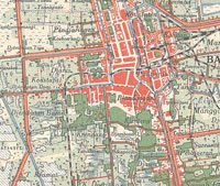
Late 19th- and early 20th-century sheet maps of Asian (or partly Asian) cities that are held at the University of Chicago Library's Map Collection.
Several of the cities portrayed in these maps are now among the world's largest, but they were all much smaller places during the years when the maps were compiled. The largest--late Qing Beijing and early 20th-century Calcutta--each had more than a million inhabitants, but they were nothing like the sprawling "megacities" of today. The cities couldn't sprawl, since most of their inhabitants got about largely on foot. Surface rail transit was initiated in many of the cities before the end of the 19th century, but it was nowhere as extensive as in major Western cities of the same period. As a result, population density in the largest of these cities was extraordinarily high.
The cities can be classed roughly into several types. Some were still quite traditional. Their morphology followed either the East Asian tradition of religiously sanctioned cardinality (example: Beijing) or the Middle Eastern one in which hardly anything but mosque alignment was centrally planned (example: Aleppo). The geography of other cities (like Bombay and Jakarta) was essentially that of the "colonial city," whose physical structure could be said to have been determined by the (sometimes contradictory) goals of efficiency, security, ethnic separation, and the comfort of the ruling class. Still other cities--Delhi and Hanoi--were older places of a traditional type with important colonial additions. No claim can be made that there ever was such a thing as an "Asian city."
View Online Collection