Late 19th- and early 20th-century European city-planning maps that are held at the University of Chicago Library's Map Collection.
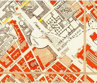
The maps take quite different approaches to the subject. Some are maps of actual plans for the future, not all of which (for example those of Cabourg and Moscow) were actually carried out. Others show land use at the moment the maps were made. Taken together, the maps support the general notion that government played a more central role in determining urban form during the latter part of the 19th- and early part of the 20th-century in Europe than in the United States. Note, for example, the plans for new housing documented in the maps of Rome that date from the 1880s. It was not until the construction of the first housing projects in the 1930s that American governments got into the housing business. Note also the elaborate land use plans from the 1920s. American cities during this period generally limited themselves to creating zoning codes. See the companion Web pages Planning Maps of Midwestern Cities in the 1920s and 1930s and Government Maps of Chicago in the 1920s, 1930s, and 1940s, and compare.
A few of the maps come from the collection of cartographic materials that was assembled by French geographer Emile Levasseur (1828-1911), bought by the old John Crerar Library in 1914, and acquired by the University of Chicago Library in 1930-1931. But most of the maps arrived as a result of a massive solicitation campaign conducted by the Map Collection's staff just after its founding in 1929. An attempt was made to acquire then-contemporary urban maps from all over the world to support the University of Chicago's distinguished urban-studies program. Few other libraries were collecting contemporary maps during this period, and most of the maps to which this page provides access seem not to be held anywhere else.
View Online Collection