The Early Modern Maps of the Americas Collection contains maps selected from the University of Chicago Library’s Map Collection and Special Collections Research Center by Jose Estrada, a doctoral candidate in the Hispanic and Luso-Brazilian Studies program within the Romance Languages and Literatures Department. Estrada’s work was supported through a Graduate Global Impact Internship provided by UChicagoGRAD.
The collection follows the representation of the Americas in early modern cartography. The maps date from the 16th through the 18th centuries giving a wide perspective of how the Americas were illustrated.
Immediately after the European encounter with the Amerindians in 1492, Europeans attempted to make sense of the newly conquered lands and their people. Explorations, wars, and expeditions soon ensued, and the most successful relied on accurate maps. Thus, cartographers and maps played an important role not only in the physical portrayal of the Americas, but also in the political, cultural, and scientific world. Maps also proved useful as tools of territorial demarcation and to keep record of demographic information.
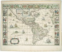
The maps in this collection range from detailed maps of Mexico, the Caribbean, North and South America, to colorful world maps that portray the engraving techniques of cartographers. Of especial interest are Willem Janszoon Blaeu’s Nova Totius Terrarum Orbis Geographica Ac Hydrographica Tabula (1635) and Americae nova Tabula (1635). The former, a synthesis of European cosmology, has the allegorical representation of the four seasons and the classical elements on either side. The allegories of the seven planets appear on top and the seven wonders of the world on the bottom. The latter has images of diverse inhabitants of the Americas on the sides while the top of the map has detailed schemas of major American cities at the time.
Other maps of interest include John Senex’s A New Map of America from the Latest Observations (1721) for the depiction of California as an island, and Gillaume Delisle’s Carte d’Amerique (1722) for the hand erasures and editions located in western Canada.
View Online Collection